Acknowledgements
- This OpenEarth introduction is developed by the Data and Knowledge Management section of the Building with Nature programme as a Deliverable of Workpackage DM 1.1
OpenEarth provides an integral approach for data, models and tools. Currently there are tens of Gb of data hosted by OpenEarthTools and over 2000 Matlab functions. Whereas initially OpenEarth faced the challenge that not enough data, models and tools were provided, currently we face the challenge that almost too much is available. This 'getting started' introduces the structure behind this overwhelming amount of information. Regardless of whether the content of OpenEarth is complex, the basic structure in which the content is provided is always simple and straightforward. OpenEarth strives for web services for data, models and tools as shown in the sketch below.
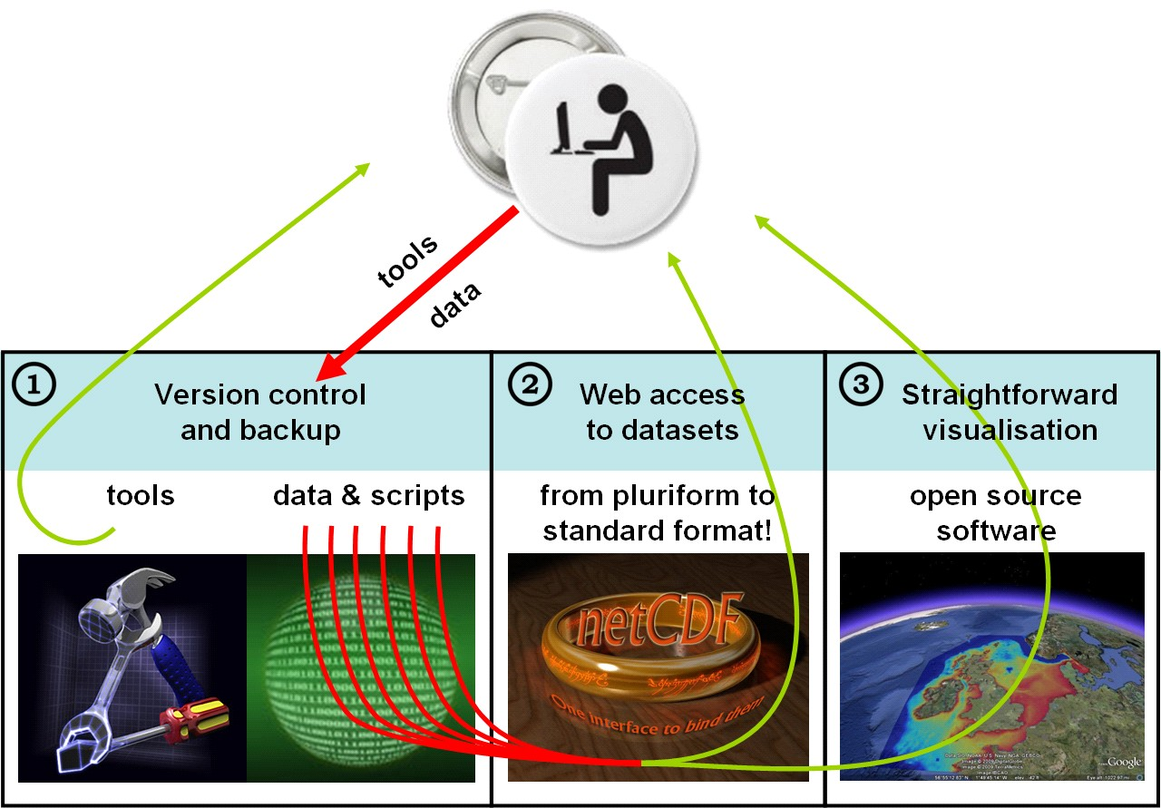
There are basically three kinds of web-services: for graphics, for data and for computer code. For graphics of data and model results OGC kml feeds (aka Google Earth feeds) are provided (3). For published data and model results an OPeNDAP server is provided (2) whereas for computer code (tools) , (unpublished) raw data and model input schematisations a Subversion repository is available (1). The workflow for users that only consume the data, models and tools is 3 > 2 > 1. This 'getting started' document is primarily meant for users that consume the data. In contrast, the workflow for the OpenEarth developers that provide all the data, models and tools is 1 > 2 > 3.
- 3. Google Earth feeds (OGC kml feeds) can be obtained without password restrictions from our kml server. Three types of kml feeds are provided:
- powerful graphics
- overview with links to powerful graphics
- overview with links to data on the OPeNDAP server
- 2. NetCDF data (published data and model results) can be obtained without password restrictions from our OPeNDAP server:
http://opendap.deltares.nl. You can access an OPenDAP server directly with a web browser, or click on deeplinks in a Google Earth overview. NetCDF is an internationally recognized file format, an OGC standard and a NASA standard that can contain an unlimited amount of meta-information. Through OPeNDAP you can access a netCDF file from a OPeNDAP server as if it were on your local computer. This removes the need to download big files, you can simply request a small portion of a file. netCDF/OPeNDAP does the same thing for data what Google Earth does for all the worlds aerial pictures: just leave all data on a server, and download only what you need, when you need it.
- 1. Tools, (unpublished) raw data and model input schematisations can be provided for free albeit with a free username password. The reason for this is that when you want to access these, you are considered a developer, and we grant you write access. To prevent misuse, and to pay proper credit to your contributions, we require all developers to request a free username. This password-controlled repository is located at https://svn.oss.deltares.nl, it uses the same Subversion technique as sourceforge. Everyone can join OpenEarth as an advanced user or a developer.
3. Easy visualisation
Powerful Google Earth visualisations, overview of visualisations and overview of OPeNDAP data
| |
2. Access to released data
Direct web access to user-defined selections of Gigabytes of well-structured data.
| |
1. Version control and backup
A growing and improving collection of free tools, tens of Gigabytes of raw data + processing scripts and model schematisations
| |