| Include Page | ||||
|---|---|---|---|---|
|
| Section |
|---|
...
IntroductionWithin |
...
| title | Acknowledgements |
|---|
...
...
(BwN) programme many data, models and tools |
...

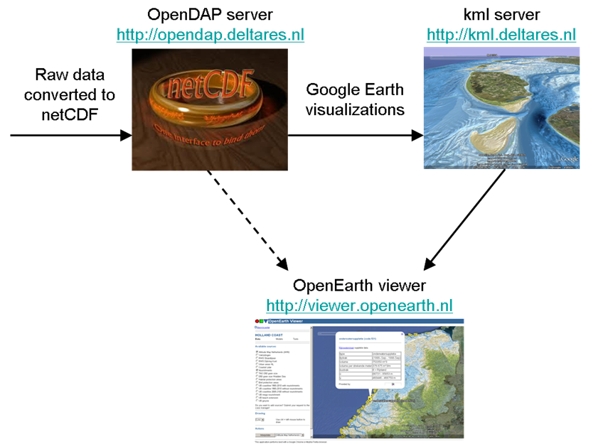
There are basically three kinds of web-services: for graphics, for data and for computer code. For graphics of data and model results OGC kml feeds (aka Google Earth feeds) are provided (3). For published data and model results an OPeNDAP server is provided (2) whereas for computer code (tools) , (unpublished) raw data and model input schematisations a Subversion repository is available (1). The workflow for users that only consume the data, models and tools is 3 > 2 > 1. This 'getting started' document is primarily meant for users that consume the data. In contrast, the workflow for the OpenEarth developers that provide all the data, models and tools is 1 > 2 > 3.
- 3. Google Earth feeds (OGC kml feeds) can be obtained without password restrictions from our kml server. Three types of kml feeds are provided:
- powerful graphics
- overview with links to powerful graphics
- overview with links to data on the OPeNDAP server
- 2. NetCDF data (published data and model results) can be obtained without password restrictions from our OPeNDAP server:
http://opendap.deltares.nl. You can access an OPenDAP server directly with a web browser, or click on deeplinks in a Google Earth overview. NetCDF is an internationally recognized file format and a NASA standard that can contain an unlimited amount of meta-information. Through OPeNDAP you can access a netCDF file from server as if it were on your local computer. This removes the need to download big files, you can simply request a small portion of a file. netCDF/OPeNDAP does the same thing for data what Google Earth does for all the worlds aerial pictures: just leave all data on a server, and download only what you need, when you need it.
- 1. Tools, (unpublished) raw data and model input schematisations can be provided for free albeit with a free username password. The reason for this is that when you want to access these, you are considered a developer, and we grant you write access. To prevent misuse, and to pay proper credit to your contributions, we require all developers to request a free username. This password-controlled repository is located at http://repos.deltares.nl, it uses the same Subversion technique as sourceforge. Everyone can join OpenEarth as an advanced user or a developer. The OpenEarth checkout includes the latest XBeach software and documentation, see and join XBeach.org to become a member of that community. A manual on the use of SubVersion explains how to get acces to the OpenEarthTools.
...
are collected and/or developed. The enormous amount of information that is becoming available this way, is not always easily accessible for low-end users. Therefore, a web application (viewer.openearth.nl) has been developed to provide an overview of all this information on a case-by-case basis (see screenshot). This application aims to visualize data, models and tools that have been made available on the OpenDAP and kml servers, as indicated in the figure below. Furthermore, it is possible to perform some basic actions on the data (e.g interpolation along a line, plotting timeseries). The web application is developed as a part of Workpackage DM 1.3 of the BwN programme. The set-up of the web application allows for flexible usage in various projects, both within and outside the BwN programme. As long as the data is in NetCDF-format, it can easily be converted into kml and visualized in the web application.
Web application set-upThe OpenEarth Viewer essentially consists of two building blocks: (1) a web layer handling user input and visualizing output and (2) a (Matlab/python based) functional layer underneath for additional functionality such as performing actions on datasets, calling tools and running model simulations. The web layer is based on HTML and JavaScript and uses a Google Earth Plug-in and its JavaScript API to embed Google Earth in the web application. The web layer is sufficient if one wants to use the application exclusively for viewing datasets and model outlines/results. However, if one wants to add (Matlab or python based) interactivity to the application, the functional layer is required as well.
Setting up your own web applicationOpenEarth Viewer - Getting access |

| Attachments | ||
|---|---|---|
|
...