
 This project has received funding from the European Union’s Seventh Framework Programme for research, technological development and demonstration under grant agreement no 607131.
The value of MI-SAFE
What is MI-SAFE?
The FAST project (Foreshore Assessment using Space Technology) has developed a package of services, the MI-SAFE package (http://www.fast-spaceproject.eu/index.php/services), to help engineering companies, governments, research institutes, NGOs and other users understand how foreshores reduce flood risk on any given shore worldwide.
Why MI-SAFE?
Flood risk is one of the most pressing challenges facing society today. To meet this challenge, environmental managers, consultants (and other market sectors) and research organisations are collecting data and developing tools to support sustainable flood risk management solutions.
Nature-based flood defence is becoming recognised as one of the most sustainable and cost-effective strategies to protect vulnerable areas. At present, however, this concept is not widely implemented. The verifiable demonstration of benefits has been lacking and it is clear that flood protection engineers need trusted and practical tools that provide them with the desired quantitative information on key flood hazard parameters.
The knowledge provided by MI-SAFE will address this need and help to reduce the cost of flood protection as well as assisting efforts towards a more wide-spread and successful restoration and conservation of coastal ecosystems.
Unique services
Our focus is to deliver smart services that will allow you to include ecosystem-engineering concepts into coastal protection: the MI-SAFE package.
The main vehicle for demonstrating our services is a user-friendly online viewer, the MI-SAFE viewer, estimating automatically the impact of foreshores on flood hazards and predicting potential contributions of nature-based flood defences towards flood risk reduction efforts. The MI-SAFE viewer is based on the principles of Nature-based flood defence and gives you access to global open source data and model predictions, as well as local information for a series of case studies. The project delivers new high-resolution spatial information layers for all coasts of the world.
Our services are unique because they are:
- Pioneer on providing world-wide coastal flood hazard related parameters;
- A combination of worldwide coastal coverage and high-resolution local analysis;
- Based on transparent and verifiable scientific insights;
- Using automated coupling of Earth Observation, water level, wave and vegetation modelling;
- Based on Open Geospatial Consortium (OGC) data streams – to be used with your own system, with free access and in standard formats;
- Built with Open Source tools - adaptable to your own tool chain;
- Supported by the Open Earth open source and free software community;
- Versatile, with advanced functionalities for end users that cater to your specific needs.
The MI-SAFE package
The MI-SAFE package includes an accessible set of products and services accessible and demonstrated through a user-friendly online viewer: the MI-SAFE viewer.
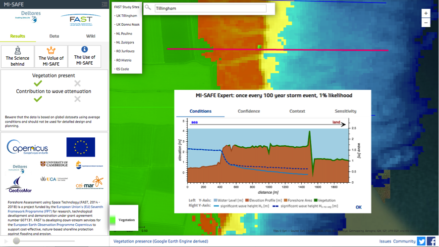
Figure 1. Screen shot of MI-SAFE viewer showing an example of Expert level services for one FAST study site: Tillingham saltmarsh (UK).
The MI-SAFE viewer is designed to quickly and efficiently evaluate wave transformation to a foreshore. Using the ‘Educational level' of services in the viewer, the user can click on any foreshore in the world, automatically generating a quick assessment of the slope of the terrain and whether vegetation is present and contributing to wave height reduction. Wave attenuation and crest height reduction are estimated, depending on elevation, hydraulic boundary conditions and type of vegetation present. For specific case study sites, the MI-SAFE viewer offers results that are calibrated and validated to a higher quality and delivers additional and more detailed data layers (our ‘Expert level' of services).
To generate this information, FAST has gathered, reclassified and produced open format layers of geographical information; using Earth Observation resources (e.g. Sentinel satellite images), and data collected in situ by the FAST team. These layers, together with the intensive scientific fieldwork that underpins FAST, have been used to establish relationships between elevation, vegetation properties, water level and wave dynamics. Those relationships have been used to calibrate the open software wave model XBeach and thus to estimate the effects of foreshore vegetation on wave attenuation and sea wall overtopping. For further technical and scientific details on MI-SAFE products and services see the public link 'the Science behind MI-SAFE'.

Figure 2. Summary of the MI-SAFE package. The MI-SAFE viewer is a key element to access the Educational (blue), Expert (brown) as well as the Advanced level services (green). The logos of the team of experts supporting MI-SAFE are included.
In addition to the Educational and Expert levels, the MI-SAFE package offers opportunities for generating tailor-made solutions for users with nature-based coastal defence issues (Advanced level services, see Figure 2).
Services
The MI-SAFE package provides different types of services at three different levels. This section describes details of the types of services and the scope of the corresponding levels.
Types of services
The MI-SAFE package offers two types of services:
- Open Geospatial Consortium data streams (OGC data): This service is accessible via the MI-SAFE viewer and available via MI-SAFE GeoNetwork CSW catalogue (Educational and Expert level services), similar products can be generated by the FAST team on request (Advanced level services).
- Elevation (bathymetry and topography)
- Vegetation (presence, leaf-area-index, types)
- Wave and water level statistics (significant wave height (Hs), tidal range)
- Open Source Modelling (OS modelling): This service is accessible via the MI-SAFE viewer (Educational (global scale) and Expert level services (FAST study sites)); it also includes calibration/validation for new sites and the modelling of new processes on request (Advanced level services).
- XBeach with vegetation for coastal, delta and riparian regions, calibrated and validated by FAST for study cases.
- Flexible integration using OGC data streams (inputs and outputs). Built into Delft Dashboard - easy connection to Delft3D, XBEACH, SWAN, and many other Open software models also built into Delft Dashboard.
- Open data and open source based on Open Earth conventions.
- Link to open access projects on coastal status such a RISC-KIT and Coastal Hazard Wheel
The main vehicle for demonstrating these services is the MI-SAFE viewer, a user-friendly online viewer that gives access to the MI-SAFE package on-lines resources and provides ways to interact with the FAST team.
The services of the MI-SAFE package are structured as an open source platform where the partners of the FAST team cooperate to support and maintain these services. This structure facilitates the access to multi-services provided by and based on each partners expertise in relation to and extending upon the products and services identified in the MI-SAFE package. Additionally, to strengthen the availability, the promotion and the maintenance of services, the MI-SAFE package has also been linked to existing open source data platforms and tools such as:
- Deltares OSS community: http://oss.deltares.nl/
- XBeach modelling community: https://oss.deltares.nl/web/xbeach/
- Delft Dashboard: https://oss.deltares.nl/web/delft3d/general/-/message_boards?_19_mbCategoryId=410221
Levels of services
The MI-SAFE package provides OGC data and OS modelling services at three different levels with different spatial scale and quality: Educational (global), Expert (study site high-resolution) and Advanced (tailor made solutions). The specific details and services of the three levels of the MI-SAFE services and how to access these services are described in the sections below.
The MI-SAFE Educational level
At the Educational level, the MI-SAFE package provides services at global scale (Figure 3). The services at this level provide quick scan answers to questions about wave attenuation and crest height reduction over the foreshore, displaying a summary of wave transformation along cross-shore profiles while providing relevant context maps. The quality and spatial resolution of the outputs are limited by the global quality of the input data layers. The MI-SAFE viewer provides users with easy access to the global open data layers. As main value, this service offers a first indication of the presence and potential flood risk reduction effects of foreshores anywhere across the globe, including data scarce regions. The purpose of this service is to give a preliminary evaluation of areas where foreshore vegetation may be contributing to coastal defence.
Beside the OGC data and OS modelling services, this level provides access to our scientific basis ('The science behind the MI-SAFE package') and a set of methodological videos to produce similar products with our scientific standards ('FAST methodological videos').
Our global scale products are available for sites that differ from the FAST study cases, using online global maps of water depth, elevation, and vegetation coverage derived from space-borne sensors, and with wave and storm surge conditions derived from global ocean models.

Figure 3. Example of MI-SAFE Educational level service. Combination of elevation, tidal range, wave height and vegetation presence layers to estimate areas where foreshore vegetation has a potential contribution to reduce flood risk in Europe. All these layers are available via the Global Base maps of the MI-SAFE viewer at the MI-SAFE GeoNetwork CSW catalogue.
In summary, the Educational level of the MI-SAFE package includes:
 |
|
The MI-SAFE Expert level
At the Expert level, the MI-SAFE package provides for FAST study sites higher quality services than offered at the Educational level (Figure 1). Although the MI-SAFE viewer has no real distinction in between levels of services, the Expert level includes more detailed maps, results calibrated and validated to a higher quality and additional data layers for the FAST study sites. To produce this level of services, the FAST team calibrated and validated open data layers and XBeach with detailed local information on vegetation, bathymetry and waves (case study data). For FAST study sites, the MI-SAFE Expert mode uses the same storm conditions as the Educational version, but provides more details on underlying parameters, generating higher quality and resolution outputs (Figure 1).
The FAST team has implemented procedures based on INSPIRE metadata conventions to ensure our products are fully documented. An active open source community will be ready for any questions related to the MI-SAFE viewer. This is led by the FAST team who are familiar with the viewer and able to support its use and linked to the facilities and training provided by Deltares during the international Delft Software Days.
Specifically, the services of the MI-SAFE Expert level include:
 |
|
The services and products of the MI-SAFE Educational and Expert levels are freely available through the MI-SAFE viewer, after acceptance of the MI-SAFE non-commercial service level agreement.
The MI-SAFE Advanced level
For end-users with specific Nature-based coastal defence needs, the MI-SAFE package offers the Advanced level of services. This level offers the most versatile services of MI-SAFE on request via tailor made solutions that can go from validation/calibration of new sites to development of new functionalities. To access the Advanced level of services, end-users have to contact with the FAST team (see section 5). The partners of the FAST team are renowned international experts on coastal Nature-based Solutions (NbS) with capacity to provide tailor-made solutions on Nature-based coastal defence issues. The Advanced level include as services on demand:
- OGC data services: Spatial products with increased spatial resolution for regional and local studies and increased information on storm surge impacts following FAST protocols and map-outputs. The generation of these products may include in situ and/or remote (Earth Observation) data collection, processing and reporting, or uploading of increased resolution maps in geoserver, such as elevation maps for new sites to improve outputs.
MI-SAFE can deliver OGC data services on:- Elevation data: acquired by dGPS, UAVs, air/ground Lidar, or EO.
- Vegetation data: field surveys, UAVs, EO and trend analysis.
- Wave attenuation data: field measurements, long-term deployments.
- Sediment dynamics data: field measurements and long term EO.
- OS modelling services: Development of new model functionalities, calibration and validation.
- Implementation of 1D, 2D or 3D model schematizations using full XBEACH functionality.
- Generation of new algorithms and data fusion, calibration and validation of model outputs for a specific or for different regions.
- Linking of EO data and wave modelling to other modelling toolboxes.
To provide these services, the Advanced level offers quick scan of sit and discussion of issue at hand with the FAST team. Additionally, for end-users with interest in learning how to get the maximum benefit from the MI-SAFE services, there is also an offer of starters and advanced training packages.
Depending on the specific end-user requirements, the Advanced level of services can be provided as consultancy, training and/or support. These services offer opportunities tailored to individual users including data collection, setting up EO workflows, tuning models, exploiting OGC data streams or large-scale deployments.
As examples of Advanced level services, FAST has combined products and services with those generated by the EU project RISC-KIT to estimate the risk of overtopping (XBeach, FAST) and the corresponding flooding (LISFLOOD, RISC-KIT) for our Tillingham study site (UK) (Figure 4). These examples are available in the MI-SAFE viewer for the Tillingham study site.
 A)
A)  B)
B)  C)
C)
Figure 4. A) Combination of FAST (XBeach-VEG) and RISC-KIT (LISFLOOD) elements used to generate an advanced service modelling overtopping and inundation due to the impact of a large storm on a vegetated foreshore. B) XBeach 3D non-hydrostatic model of impact of a large storm at Tillingham saltmarsh (UK). C) LISFLOOD simulation of inundation impact of a large storm at Tillingham saltmarsh (UK).
The services of the Advanced level has to be defined in interaction with the FAST team in the corresponding commercial service level agreement. As a summary, these services can include:
 | OGC data
OS modelling Building new functionalities such as:
Advanced flooding, inundation, damage analysis making use of couplings of FAST with the RISC-KIT toolbox, Coastal Hazard Wheel and Delft3D software. Advice and training
|
The MI-SAFE services summary
This section summarizes the main services of the MI-SAFE package and the way of access (Table 1). The Educational and Expert level services are fully accessible via the MI-SAFE viewer, allowing visualization and access to freely download these products from the MI-SAFE GeoNetwork CSW catalogue. The Advanced level services are offered only on request by contacting with the FAST team. The MI-SAFE viewer has two forms (community and issue forms) to get support with the MI-SAFE viewer and contact with the FAST team (see section 5 for other ways to contact the FAST team).
Table 1. Summary of the MI-SAFE services, including a short description and corresponding access. MI-SAFE viewer indicates Educational and Expert level services freely available in the MI-SAFE viewer. MI-SAFE Advanced indicates services only offered on request. Several examples of Advanced level services are already available in the MI-SAFE viewer for our Tillingham study site (UK).

Contact with the FAST team
There are several ways to contact the FAST team: (1) Fill in the community form or the issue form available in the MI-SAFE viewer, (2) contact via the FAST web page by sending a contact message or contacting an specific partner of the FAST team or (3) send a message to the FAST twitter account (@FP7FAST), to the FAST Facebook page (FastSpaceProject) or to MI-SAFE twitter account (@MISAFE_services).