Introduction
...
Deltares has already investigated several sediment management strategies using a 1D-model to investigate the behavior of the system. This has been done by implementing the software D-FlowFM, which uses a flexible mesh grid. However, the hydrodynamics of the system has not been adequately modeled yet, since the operational behavior of the dams is not known. Fortunately, some historical data is available in the form of inflow, spillway and generator discharges and reservoir water levels from the years 1998 up to 2007. The aim of this report is to find a way to model the operational behavior of the dams such that the behavior is as close to the observed behavior. In their turn these findings can be used to model additional scenarios for the dam behavior, in order to find the most optimal dam behavior in combination with the proposed sediment strategies.
Background (Mud, sand, gravel, nourishment, and RTC modelling in 1D)
A river with a cascade dam system, like Tenryuu River (Japan), requires complex management to obtain a sustainable ecosystem. Synchronization of sediment management in a cascade dams’ system is an important issue to ensure proper environmental management of a river system. There is a need to provide modelling tools with high capability to investigate and improve the management approaches of sediment routing.
A reach of the Tenryuu River is studied using the 1D modelling tool of Delft3D Flexible Mesh. For modelling the dams, coupling to D-RTC is essential. Modelling of both cohesive and non-cohesive sediment is necessary. The first for assessing the ecological impact of the reservoirs management, and the second for assessing the morphodynamic impact. Moreover, it has been made possible to model nourishments in 1D for accounting for the strategies currently being implemented by the river manager.
For details please contact Victor Chavarrias or Amgad Omer.

Figure 1.Bed elevation and water elevation under a high-flow event and a low-flow event.
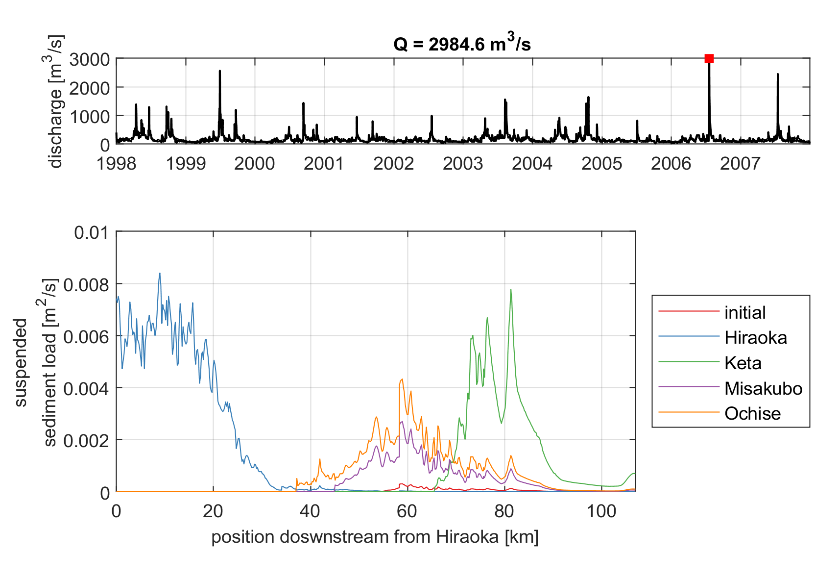
Figure 2. Mud concentration along the river. The mud from each tributary as well as the initially present at the bed surface are modelleded independently.
Progress (Tenryū model overview)
The model used is an adjusted model of the r_066 simulation for the Tenryū project. Overview of the type of simulations is given below. Two main type of simulations are done, for both a weir and a gate. The weir simulations have little significance, since spillway gates are used.
...
Simulation type
...
Simulation time
...
Simulation amount
...
Comment
...
Gate simulations
...
1 years
...
388
...
Only simulations are done for the year 2007
...
...
5 years
...
62
...
Simulations are done for both periods 1998-2002 and 2003-2007
...
...
10 years
...
2
...
Simulations are done for the years 1998-2007
...
...
10 years using timerule
...
1
...
Simulations are done for the years 1998-2007
...
Weir simulations
...
2 months
...
52
...
Simulations are done for Jan & Feb 2007.
...
Structures
Structure type: General structure (Gate)
...
...
Crest height
...
Crest width
...
Comments
...
Sakuma
...
220
...
75
...
Assumed
...
Akiba
...
94.5
...
130
...
Real values
...
Funagira
...
42
...
180
...
Real values
...
The report of this investigation can be seen here.