...
Following a successful JIP CoDeS Pilot, Royal HaskoningDHV, Witteveen+Bos and Deltares continued the Joint Industry Project (JIP) with CoDeS 1.0.

Figure 1: CoDeS tool to quickly assess alongshore sediment transport rates at the coastOVerview of the CoDeS tools framework in which tools from different disciplines related to the design of coastal engineering are brought together.
Objectives
The objectives of JIP CoDeS 1.0, following the developments made within the JIP CoDeS Pilot, are defined as follows:
- to extend the CoDeS tools within the Delta Shell framework in terms of functionality, uniformity, interactivity and number of tools available
- to continue the joint creation of an easily accessible platform for the exchange and dissemination of CoDeS tools and knowledge within
- to further grow the active community of developers (and users) amongst the different partners
- to build a showcase (case study) to interest potential future partners and clients, while showcasing all CoDeS 1.0 capabilities
...
A team of coastal engineers, programmers and managers (product owners) from the three JIP partners work together on tool development in sprint sessions following a SCRUM alike methodology, following the positive feedback on such methodology from the CoDeS pilot. Each sprint session has a clear scope and clear roles and responsibilities for the team. During the sprint sessions engineers and programmers use scripting (Iron Python and C#) to program CoDeS tools and link them to the Delta Shell user interface to make them easily accessible to the user community. A supporting In addition to the first (pilot) stage, a generic data framework module is setup during added to the first JIP CoDeS sprint sessionframework, in order to support uniformity, integration and interactivity throughout the different CoDeS tool developments.
...
tools. Furthermore, first steps have been made to add testes to the CoDeS framework to validate the functioning of the tools and secure robustness when more tools are added to the framework in the future.
Results
JIP CoDeS 1.0 is divided in two sepate sets of a number of sprint sessions, each followed subdivided into three sets of sprint sessions. All these sprint sessions were concluded by a demo of the present status developed product to both the product owners and advisory board . Within these demos feedback is provided in order to steer subsequent developments. The following CoDeS demos are part of JIP CoDeS 1.0:
- February 12, 2016
- April 13, 2016
Following the second demo, a 'bug fixing' sprint session is planned, in which minor bugs encountered during the second demo are resolved, as well as further 'quick wins' implemented towards product finalization.
Product
The envisioned product is a uniform GUI containing tools for:
- handling generic data uniformly available for the different CoDeS tools
- bathymetry data import
- wave data import and classification
- defining structures, a coastline and other spatial variables
- wave transformation based on linear wave theory
- tidal data import and calculation of tidal characteristics (Figure 3)
- alongshore sediment transport rate calculations (Figure 1)
- coastline evolution as a consequence of alongshore sediment transport gradients, as well as human interventions
- flow field prediction along a predefined harbour design
- breakwater design, optimization and (cost) quantification (Figure 2)
- wave penetration (short crested) within a harbour design
Within the GUI users can manually specify or load data in simple ASCII formats or import data from global data sources - if no site-specific data is available. Based on the data, users can perform simple analyses and apply empirical engineering formulae. The results are shown in a unified map, graph or table, which the user can export as images for reporting purposes. The product forms a strong basis and a wide range of opportunities for future tool developments.
(AB) for feedback and steering in priorities for subsequent developments.
- Prototype developments of new/existing tools (basic functionality only)
- Improvements of tools based on AB feedback and integration of tools using shared data model
- Finalization: save/load functionality, testing, bug fixing, show case and delivery
Products
Compared to the JIP CoDeS pilot the CoDeS tools framework was extended with following tools and functionality (objective 1):
- Generic data module to arrange the data handling for the different CoDeS tools (Figure 2), including:
- bathymetry definition
- coastline definition
- coastal structures
- wave data import, classification and transformation
- tidal data import and classification
- Tool for the design, optimization and cost quantification of port breakwaters
- Tool for wave penetration (short crested) within a port basin
- Tool for coastline evolution due to alongshore sediment transport gradients and transport blockage by port breakwaters
- Tool for flow field prediction in and around port basin (excluded from final version as decided upon by AB)
- Save/load functionality
Apart from these be tools and extensions considerable has been put in making the framework more robust (by including a shared data model and tests) and improving the look & feel of the framework in terms of uniformity and accessibility for non-trained users. This has increased the use of the developed tools within the partners' organization considerable compared to the product of the JIP CoDeS Pilot. Moreover, the CoDeS community has become more mature in the sense that also internal and external contributions to the tools have been made outside the JIP project itself (objective 2 and 3). In order to demonstrate the use of the framework to a wider audience a showcase has been developed for the Scheveningen case. This indicative case study, illustrating the use of the tools in a real-life project, has been compiled in a conference paper which was presented at the PIANC Copdec 2016 conference in Rio de Janeiro, Brazil. The conference paper can be downloaded here (objective 4).
How do I get access to the product?
The embargo on the product was lifted in June 2017. The python code of the tools can be freely downloaded form the OpenEarth repository. You can sign up for OpenEarth on the Deltares open source website. To use the tools in conjunction with the GUI, you need to acquire Delta Shell. To this end, you can either purchase a service package of the Delft3D Flexible Mesh suite or apply for a free version of Delta Shell without support. To link the tools to the Delta Shell GUI please read the readme document.The JIP CoDeS 1.0 final product is still under development and features an embargo until April 2017. The zip version will be made available through this website as soon as the embargo is lifted.
Process
Working together in sprints using a SCRUM alike methodology was found to provide a very productive, constructive and pleasant working experience during the CoDeS pilot, and is therefore again used JIP CoDeS 1.0. In order to streamline CoDeS software development in a professional manner, the software development tool JIRA was introduced in the proceedings starting with the second set of sprint sessions following demo 1.
...
Way forward
By the end of April 2016, developments are planned to consolidate in a final JIP CoDeS 1.0 product, featuring the different tools described above.
Parties that are interested to use the tools or participate in future cooperation and development can contact Mr. Wiebe de Boer (wiebe.deboer@deltares.nl) or Mr. Freek Scheel (freek.scheel@deltares.nl).
Figure 2: CoDeS tool to assist in the design of breakwaters.
...

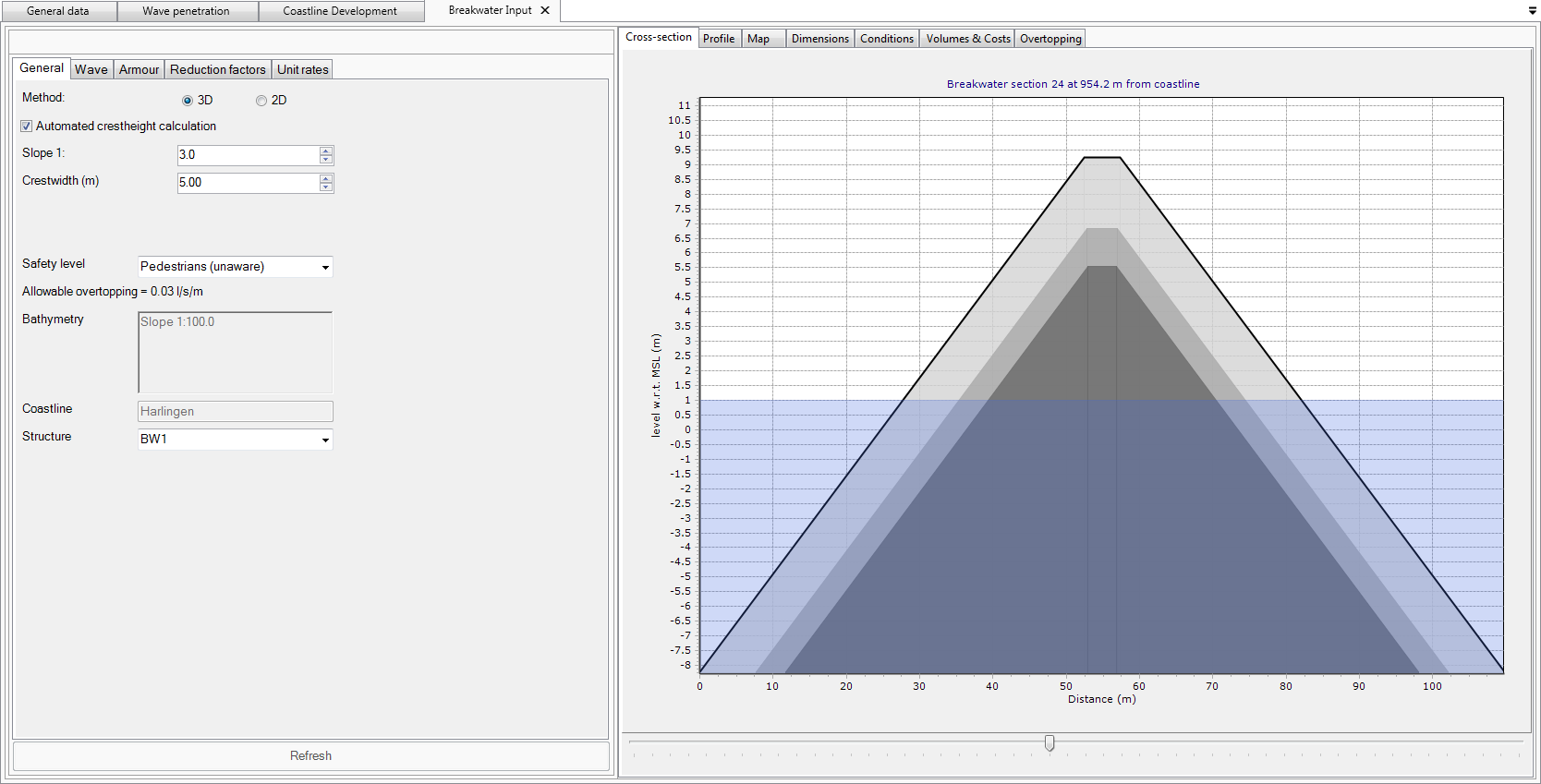


Figure 3: CoDeS tool calculating the tidal statistics at the project location.