Introduction
With a total length of approx. 225 km the Salzach river flows from the Kitzbühel Alps near Krimml in the Pinzgau region up to the confluence with the Inn in Haiming between Burghausen and Braunau. The Salzach flows in the state of Salzburg in Austria and in Bavaria in Germany. Between Wald im Pinzgau and the mouth of the Salzach, the difference in height over a 210 km flow route is a total of approx. 510 m. From Gries im Pingzau to Lehen, the Salzach is regulated by weirs. The section between Wald and Gries im Pingzau and the section between Lehen and the confluence with the Inn are free flowing.
The Saalach is one of the major tributaries which connects to the Salzach in the northern Salzburg basin. The height difference over the Saalach is approx. 110 m on a flow section of approx. 33 km.
A 1D model for the Salzach is constructed to test whether the new D-HYDRO software can be applied to mountain rivers with large differences in height, and complex steering of structures.
Method
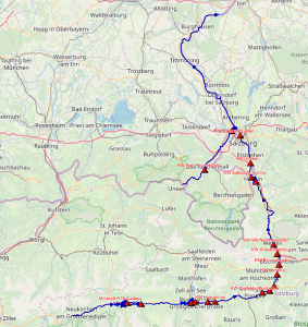
The construction of the 1D model involves the conversion of an intermediate version of the SOBEK 3.7.16 Hydrotec Prognosemodel to D-Flow - FM1D. Figure 2.1 The figure below shows the SOBEK Model structure of the Salzach river, including the Saalach tributary and the weirs (red triangles) for the hydroelectric power plants. A total of 15 weirs for hydroelectric power plants are in the Salzach and Saalach river.
For the Salzach river an advanced RTC (real time control) model is used, because not all needed RTC settings can be set in the user interface. Therefore, first a less complex regulation for all controlled structures was implemented in the user interface and then further configured to an advanced RTC model.
Results
The new D-HYDRO software can be applied to mountain rivers with large differences in height and complex steering of structures. The advanced RTC settings of the weirs and laterals function well and the pattern of water levels and discharges in FM1D resembles those of the Sobek model. Predicted water levels for the Salzach river are however in general higher in the FM model than in the SOBEK model, it seems that FM1D calculates a stronger water level slope. There are occasionally large differences (several meters) in water level observed between the respective models. Especially when the crest of the structures is almost completely or completely lowered, and the discharge peak passes. It should be analyzed why this enormous difference in water level occurs, and if the weirs and the energy losses caused by them are properly implemented in FM1D[1].
In general calculation time increases significantly in FM1D. Simulation times increases enormously due to a few less optimal grid cells in the model, and significantly due to other reasons, that still need to be found.
However, in the meantime the D-HYDRO software is further improved, so it would be recommended to repeat the simultations with the latest version, to investigate if results have improved.
[1] This problem might be caused by a bug in the way the bed level at weirs is calculated in FM. That bug was discovered at the end of the project and is solved in more recent versions of the software. Furthermore, advection at weirs is treated differently in SOBEK 3 and FM1D.
