| Wiki Markup |
|---|
| scrollbar |
Spatial Mapping
Hydrological models usually have a schematization or grid that represents the spatial resolution of the model. For groundwater models, regular or non-regular two- or three-dimensional grids may be used, whereas river models typically use a one-dimensional grid. Conceptual catchment models may use a closed polygon to describe the catchment boundary.
When models with different spatial schematizations are linked, the values associated to one schematization in the source model must be transformed to be represented on the schematization of the target model. In order to make such transformations possible for any combination of models a standardized spatial representation was defined. In OpenMI terms this is called the IElementSet interface (see Figure below).
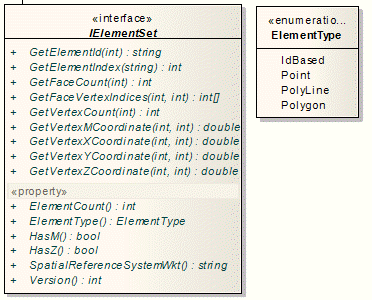
The number of ElementTypes has been reduced in OpenMI 2, e.g. the two-dimensional XYPoint and the three-dimensional XYZPoint have been melted to the ElementType Point with an optional z value.
...