...
- The Somalia waters are well-known to the Dutch, not only because their navy protects merchant vessels against the pirates, but also because it is the place where you end up if you swap our lat-lon. What a pity we ever decided to say "lat-lon" (y-x) whereas for projections we say "x-y". The OGC WMS standard has to include a special case for this: the WGS84 coordinate system EPSG:4326 lead to so many x-y swaps, a separate coordinate system CRS84 had to be introduced where the order was explicitly specified. It is also a pity that this very system EPSG:4326 is the most used system in the world. Even expensive commercial software requires manual tweaking ESRI.
 =
=  !
!
Does this look identical to you: Rotterdam harbour at (52,4) and Somalia pirates at (4,52)
...
- what are the units of this arc asc grid (m or cm)? And is the depth up or down? And did the creator remember that in the arc asc "standard" y is upside down in the file i.e. (1,1) is not the first number in the file? creator remember they the
xllcorneris not the position of the left most pixels, but the position of the left-hand side of the box surrounding that pixel? This yields already 16 (2^4) possibilities to interpret this file.
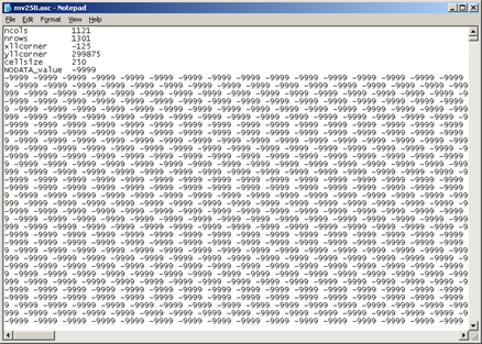
Arc ASC grid meta-data nightmare