Introduction
With a total length of approx. 225 km the Salzach river flows from the Kitzbühel Alps near Krimml in the Pinzgau region up to the confluence with the Inn in Haiming between Burghausen and Braunau. The Salzach flows in the state of Salzburg in Austria and in Bavaria in Germany. Between Wald im Pinzgau and the mouth of the Salzach, the difference in height over a 210 km flow route is a total of approx. 510 m. From Gries im Pingzau to Lehen, the Salzach is regulated by weirs. The section between Wald and Gries im Pingzau and the section between Lehen and the confluence with the Inn are free flowing.
The Saalach is one of the major tributaries which connects to the Salzach in the northern Salzburg basin. The height difference over the Saalach is approx. 110 m on a flow section of approx. 33 km.
A 1D model for the Salzach is constructed to test whether the new D-HYDRO software can be applied to mountain rivers with large differences in height,
Method
The construction of the 1D model involves the conversion of an intermediate version of the SOBEK 3.7.16 Hydrotec Prognosemodel to D-Flow - FM1D. Figure 2.1 shows the SOBEK Model structure of the Salzach river, including the Saalach tributary and the weirs (red triangles) for the hydroelectric power plants. A total of 15 weirs for hydroelectric power plants are in the Salzach and Saalach river.
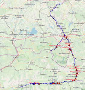
Figure 2.1 Model structure of the Salzach river with Saalach tributary. Hydroelectric powerplants are shown as red triangles.
For the Salzach river an advanced RTC (real time control) model is used, because not all needed RTC settings can be set in the user interface. Therefore, first a less complex regulation for all controlled structures was implemented in the user interface and then further configured to an advanced RTC model.
Results
The new D-HYDRO software can be applied to mountain rivers with large differences in height. The advanced RTC settings of the weirs and laterals function well and the pattern of water levels and discharges in FM1D resembles those of the Sobek model. Predicted water levels for the Salzach river are however in general higher in the FM model than in the SOBEK model, it seems that FM1D calculates a stronger water level slope.