What | nameofinstance.xml |
|---|---|
Description | Configuration for import module |
schema location | http://fews.wldelft.nl/schemas/version1.0/timeSeriesImportRun.xsd |
Entry in ModuleDescriptors | <moduleDescriptor id="TimeSeriesImportRun"> |
Time Series Import Module
The time series import class can be applied to import data from a variety of external formats. The formats are included in an enumeration of supported import types. Each of these enumerations is used for a specifically formatted file.

Figure 62 Elements of the TimeSeriesImport configuration
import
Root element for the definition of an import run task. Each task defined will import data in a specified format from a specified directory. For defining multiple formats, different import tasks reading from different directories must be defined.
general
Root element for general definitions used in the import runs.

description
Optional description for the import run. Used for reference purposes only.
importType
Specification of the format of the data to be imported. The enumeration of options includes for example:
- MSW : Import of data provided by the MSW System (Rijkswaterstaat, the Netherlands).
- KNMI : Import of synoptic data from KNMI (Dutch Meteorological Service).
- WISKI : Import of time series data from the WISKI Database system (Kisters AG).
- DWD-GME : Import of NWP data of the DWD Global Modell, (German Meteorological Service). This is a grid data format.
- DWD-LM : Import of NWP data of the DWD Lokal Modell, (German Meteorological Service). This is a grid data format.
- GRIB : Import of the GRIB data format. General format for exchange of meteorological data.
- EVN: Import of data in the EVN format (Austrian Telemetry)
- METEOSAT: Import of images form meteosat satellite
The complete list of possible importTypes is listed here
folder , server Url or jdbc connection
Location to import data from. This may be a UNC path (ie located on the network), sftp, http or from a database.
JDBC example:
<general>
      <importTypeStandard>database</importTypeStandard>
      <jdbcDriverClass>com.mysql.jdbc.Driver</jdbcDriverClass>
      <jdbcConnectionString>jdbc:mysql://192.168.101.215/cwb_ac</jdbcConnectionString>
      <user>sobek</user>
      <password>Tohek>cwa</password>
      <relativeViewPeriod startOverrulable="true" endOverrulable="true" start="-1" end="1" unit="day"/>
      <table name="qpe_sums_obs">
        <dateTimeColumn name="rehdate"/>
        <valueColumn name="rad_gz" unit="mm/hr" locationId="Qesums" parameterId="P.radar.actual" parser="Mosaic"/>
      </table>
      <table name="qpe_sums_fo">
        <forecastDateTimeColumn name="createdate"/>
        <dateTimeColumn name="raddate"/>
        <valueColumn name="rad_gz" unit="mm/hr" locationId="Qpesums" parameterId="P.radar.forecast" parser="Mosaic"/>
      </table>
      <unitConversionsId>ImportUnitConversions</unitConversionsId>
      <importTimeZone>
        <timeZoneOffset>+00:00</timeZoneOffset>
      </importTimeZone>
      <dataFeedId>QPE_Sum</dataFeedId>
    </general>
sftp example:
<general>
      <importType>TypicalAsciiForecast</importType>
      <folder>sftp://wf:2004wrf@130.167.66.114:22/home/WRF</folder>
      <relativeViewPeriod startOverrulable="true" endOverrulable="true" start="-1" end="3" unit="day"/>
      <unitConversionsId>ImportUnitConversions</unitConversionsId>
      <importTimeZone>
        <timeZoneOffset>+00:00</timeZoneOffset>
      </importTimeZone>
      <dataFeedId>Forecast</dataFeedId>
    </general>
http example:
<general>
      <importType>RemoteServer</importType>
      <serverUrl>http://192.168.65.12:8002</serverUrl>
      <relativeViewPeriod startOverrulable="true" endOverrulable="true" start="-1" end="0" unit="day"/>
      <idMapId>IdImportRO</idMapId>
      <importTimeZone>
        <timeZoneOffset>+10:00</timeZoneOffset>
      </importTimeZone>
      <dataFeedId>RO</dataFeedId>
    </general>
When using the serverUrl (http), then it is also possible to use tags in the serverUrl. Tags should be separated by "%" signs. The following tags can be used in this URL. %TIME_ZERO(dateFormat)% is replaced with the time zero of the import run. The time zero is formatted using the dateFormat that is specified between the brackets. For example %TIME_ZERO(yyyyMMdd)% would be replaced with the year, month and day of the time zero. %RELATIVE_TIME_IN_SECONDS(dateFormat,relativeTime)% is replaced with time = (time0 + relativeTime), where time0 is the time zero of the import run and relativeTime is a time relative to time0 in seconds (can be negative). The time is formatted using the dateFormat that is specified as the first argument between the brackets. For example %RELATIVE_TIME_IN_SECONDS(yyyyMMdd,-18000)% would be replaced with the year, month and day of time = time0 - 18000 seconds. Examples of serverUrls with tags in it:
<serverUrl>http://nomads.ncep.noaa.gov:9090/dods/gfs/gfs%TIME_ZERO(yyyyMMdd)%/gfs_%TIME_ZERO(HH)%z</serverUrl>
<serverUrl>http://nomads.ncep.noaa.gov:9090/dods/gfs/gfs%RELATIVE_TIME_IN_SECONDS(yyyyMMdd, -18000 )%/gfs_%RELATIVE_TIME_IN_SECONDS(HH,-18000)%z</serverUrl>
failedFolder
Folder to move badly formatted files to. This may be a UNC path (ie located on the network).
fileNamePatternFilter
e.g *.xml to skip non xml files. Only the * and ? wild cards are recognized.
fileNameObservationDateTimePattern
'IMAGE_'yyyyMMdd_HHmmss'.jpg' This will overrule the observation time stored in the file, some grid formats don't contain the time at all, so for these files the pattern is required. Put the literal parts of the pattern between single quotes.
fileNameForecastCreationDateTimePattern
'IMAGE_'yyyyMMdd_HHmmss'.jpg' This will overrule the forecast time stored in the file, some grid formats don't contain the forecast time at all, so for these files the pattern is required. Put the literal parts of the pattern between single quotes. When the file name also contains non forecast date times. Put this parts between ' and use ? wildcard. All forecast with the same forecast time belong to the same forecast.
When filename starts with the pattern do not use quotes in at the start: yyyyMMdd'_bla.nc'
fileNameLocationIdPattern
Use the filename, or part of it, as the locationId for the TimeSeries that will be imported
fileNameParameterIdPattern
Use the filename, or part of it, as the parameterId for the TimeSeries that will be imported
user
User name, required when importing from protected database connections or protected servers.
password
Password, required when importing from protected database connections or protected servers.
relativeViewPeriod
The relative period for which data should be imported. This period is relative to the time 0 of the run. When the start and end time are overrulable the user can specify the download length with the cold state time and forecast length in the manual forecast dialog. It is also possible to import data for an absolute period of time using the startDateTime and endDateTime elements.
startDateTime
Start date and time of the (absolute) period for which data should be imported. Start is inclusive. This dateTime is in the configured importTimeZone. It is also possible to import data for a relative period of time using the relativeViewPeriod element.
endDateTime
End date and time of the (absolute) period for which data should be imported. End is inclusive. This dateTime is in the configured importTimeZone. It is also possible to import data for a relative period of time using the relativeViewPeriod element.
table
Currently the generalCsv and Database import require a table layout description configured by the user. Non-standard imports (plugins) can also require a table layout. See the documentation of the specific import.
Table Layout
failOnUnmappableTimeSeries
This optional element lets the imported file to be moved to the failedFolder in case the file contains time series that are not mapped to time series in the import module. Very usefull for testing if you do not expect unknown time series to be imported. Default value is FALSE.
failOnUnmappableLocations
This optional element lets the imported file to be moved to the failedFolder in case the file contains locations that are not mapped to locations in the import module. Very usefull for testing if you do not expect unknown time series to be imported. Default value is FALSE.
logWarningsForUnmappableTimeSeries
When true warnings are logged when time series in the imported files are skipped. By default unmappable time series are silently skipped
logWarningsForUnmappableLocations
When true warnings are logged when locations in the imported files are skipped. By default unmappable locations are silently skipped
logWarningsForUnmappableParameters
When true warnings are logged when parameters in the imported files are skipped. By default unmappable parameters are silently skipped
logWarningsForUnmappableQualifiers
When true warnings are logged when qualifiers in the imported files are skipped. By default unmappable qualifiers are silently skipped
idMapId
ID of the IdMap used to convert external parameterId's and locationId's to internal parameter and location Id's. Each of the formats specified will have a unique method of identifying the id in the external format. See section on configuration for Mapping Id's units and flags.
useStandardName (since stable build 2012.02)
Optional. When the parser provides the standard name the parameter mapping can be done by matching the standard name. The standard name of the parameter in the time series set should be configured in the parameters.xml and the standard name should be provided by the import format. If not an error is logged. When also the maximumSnapDistance is configured no id map is required at all.
maximumSnapDistance
Since 2012.02. Optional maximum horizontal snap distance in meters. When the parser provides horizontal location coordinates (x,y) and no locationIds, then the location mapping will be done by matching the horizontal coordinates. The horizontal snap distance is the tolerance used to detect which internal and external horizontal coordinates are the same. Don't forget to configure the geoDatum when the input format does not provide the coordinate system for the locations. When the parser does not provide the coordinates for a time series an error is logged. Note: this option has no effect for grid data. Note 2: it is not possible to import data using horizontal coordinates and using locationIds in the same import, need to define separate import elements for that (one with maximumSnapDistance and one without maximumSnapDistance).
maximumVerticalSnapDistance
Since 2014.02. Optional maximum vertical snap distance in meters. When the parser provides vertical location coordinates (z) and no locationIds, then the location mapping will be done by matching the vertical coordinates. The vertical snap distance is the tolerance used to detect which internal and external vertical coordinates are the same. This only works when the input format provides the coordinates of the locations. When the parser does not provide the vertical coordinates for a time series an error is logged. Note: this option currently only works for importing horizontal layers from netcdf 3D grid data. Note 2: it is not possible to import data with z-coordinates (layers from 3D grids) and data without z-coordinates (2D grids) in the same import, need to define separate import elements for that (one with maximumVerticalSnapDistance and one without maximumVerticalSnapDistance).
unitConversionsId
ID of the UnitConversions used to convert external units to internal units. Each of the formats specified will have a unique method of identifying the unit in the external format. See section on configuration for Mapping Id's units and flags.
flagConversionsId
ID of the FlagConversions used to convert external data quality flags to internal data quality flags. Each of the formats specified will have a unique method of identifying the flag in the external format. See section on configuration for Mapping Id's units and flags.
missingValue
Optional specification of missing value identifier in external data format.
importTimeZone
Time zone the external data is provided in if this is not specified in the data format itself. This may be specified as a timeZoneOffset, or as a specific timeZoneName.
importTimeZone:timeZoneOffset
The offset of the time zone with reference to UTC (equivalent to GMT). Entries should define the number of hours (or fraction of hours) offset. (e.g. +01:00)
importTimeZone:timeZoneName
Enumeration of supported time zones. See appendix B for list of supported time zones.
gridStartPoint
Identification of the cell considered as the first cell of the grid. This may be in the upper left corner or in the lower left corner. Enumeration of options include;
- NW : for upper left
- SW : for lower left
logErrorsAsWarnings
Some not parser-specific log messages such as " Import folder ... does not exist" or " Can not connect to..." can be logged as Error or as Warning. Use this option to change it. Default is logErrorsAsWarnings=true. Configure false if you wish clear alert notifications in SystemMonitor and Explorer statusBar
Available since 2014.01
dataFeedId
Optional id for data feed. If not provided then the folder name will be used. This is is used in the SystemMonitorDisplay in the importstatus tab.
actionLogEventTypeId
ID of the action message that must be logged if any data imported. This message is then used to start up an action as configured in the MasterController config.files (e.g. start a forecast)
comment
You can add a comment by the importmodule to the first imported value (or all values) by using the commentForFirstValue or commentForAllValues element.
The next tags are possible within the comment: %IMPORT_DATE_TIME%, %FILE_DATE_TIME%, %FILE_NAME%
Time formats can be configured through the timeZone and dateTimePattern elements.
relativeStartTime
Optional forecast time relative to the T0 of the import run. All imported external forecast time series will get this forecast time. This overrules any forecast times stored in the imported data itself. All time series with the same forecast time belong to the same forecast.
skipFirstLinesCount
Skips the first n lines of a ASCII file (like CSV). Error is logged when this option is configured for a binary file.
tolerance
Definition of the tolerance for importing time values to cardinal time steps in the series to be imported to. Tolerance is defined per location/parameter combination. Multiple entries may exist.
Attributes;
- locationId : Id of the location tolerance is to be considered for.
- parameterId : Id for the parameter tolerance is to be considered for.
- timeUnit : Specification of time units tolerances is defined in (enumeration).
- unitCount : integer number of units defined for tolerance.
startTimeShift
Specification of a shift to apply to the start time of a data series to be imported as external forecasting. This is required when the time value of the first data point is not the same as the start time of the forecast. This may be the case in for example external precipitation values, where the first value given is the accumulative precipitation for the first time step. The start time of the forecast is then one time unit earlier than the first data point in the series. Multiple entries may exist.
startTimeShift:locationId
Id of the location to apply the startTimeShift to.
startTimeShift:parameterId
Id of the parameter to apply the startTimeShift to.
temporary
Since 2013.01. The time series are imported as temporary. When true it is not necessary to add the locations/parameters to the locations.xml and parameters.xml
columnSeparator and decimalSeparator
Since 2016.01 (so far only implemented for GeneralCsv import type) it is possible to choose from multiple column separators: comma "," or semi-colon ";" or pipe "|" or tab "	" or space " "
When specifying a column separator it is compulsory to also specify the decimal separator as comma "," or point "."
For example see generalCsv import type.
properties
Available since Delft-FEWS version 2010.02. These properties are passed to the time series parser that is used for this import. Some (external third party) parsers need these additional properties. See documentation of the (external third party) parser you are using.
timeSeriesSet
TimeSeriesSet to import the data to. Multiple time series sets may be defined, and each may include either a (list of) locationId's ar a locationSetId. Data imported is first read from the source data file in the format specifed. An attempt is then made to map the locationId's and the parameterId's as specified in the IdMap's to one of the locations/parameters defined in the import time series sets. If a valid match is found, then the time values are mapped to those in the timeSeriesSet, taking into account the tolerance for time values. A new entry is made in the timeSeries for each valid match made.
For non-equidistant time series the time values imported will be taken as is. For equidistant time series values are only returned on the cardinal time steps. For cardinal time steps where no value is available, no data is returned.
externUnit
For some data formats an external unit is not defined in the file to be imported. This elements allows the unit to be specified explicitly. This unit is then used in possible unit conversions.
Attributes;
- parameterId: Id of the parameter for which a unit is specified. This is the internal parameter Id.
- unit: specification of unit. This unit must be available in the UnitConversions specified in the unitConversionsId element.
gridRecordTimeIgnore
Boolean flag to specify if the start of forecast is read from the GRIB file or if it is inferred from the data imported. In some GRIB files a start of forecast is specified, but the definition of this may differ from that used in DELFT-FEWS.
When importing grid data from file formats where the attributes of the grid is not specified in the file being imported (ie the file is not self-describing), a definition of the grid should be included in the Grids configuration (see Regional Configuration).
It is also advisable to define the Grid attributes fro self describing Grids such as those imported from GRIB files. If no GRIB data is available, then DELFT-FEWS will require a specification of the grid to allow a Missing values grid to be created.
interpolateSerie
The timestep of some datasets grows larger as their forecast goes further into the future. For example; the regular timestep is 3 hours, but after 24 hours it increases to 6 hours. This element then allows the dataset to be imported with a 3 hour timestep and will interpolate when the dataset reaches 6 hours.
Attributes;
- parameterId: Id of the parameter for which a unit is specified. This is the internal parameter Id.
- interpolate: boolean flag to specify whether to interpolate for this parameter or not.
Example: Import of Meteosat images as time-series
Meteosat Images are generally imported as images in [filename].png format. The Meteosat images constitute a time series of png images, that are geo-referenced by means of a specific world file. Each image needs its own world file, which in case of PNG carries the extension [filename].pgw .
Import of images in another format, such as JPEG is also possible. The corresponding world file for a JPEG file has the extension [filename].jpg .
The images are imported via a common time series import, for which a specific image parameter needs to be specified in a parameterGroup via the parameter id image .
<parameterGroup id="image">
       <parameterType>instantaneous</parameterType>
       <unit>-</unit>
       <valueResolution>8</valueResolution>
       <parameter id="image">
       <shortName>image</shortName>
       </parameter>
</parameterGroup>
The value resolution indicates the resolution of the values of the pixels (grey tones) in the Meteosat images. In this case 8 grey tones are resampled into a single grey tone for storage space reductions. In the module for the timemeseries import run for a Meteosat image the import is then configured as follows:
<import>
    <general>
        <importType>GrayScaleImage</importType>
        <folder>$REGIONHOME$/Import/MeteoSat</folder>
             <idMapId>IdImportMeteosat</idMapId>
    </general>

    <timeSeriesSet>
        <moduleInstanceId>ImportMeteosat</moduleInstanceId>
        <valueType>grid</valueType>
        <parameterId>image</parameterId>
        <locationId>meteosat</locationId>
        <timeSeriesType>external historical</timeSeriesType>
        <timeStep unit="minute" multiplier="15"/>
        <readWriteMode>add originals</readWriteMode>
        <synchLevel>4</synchLevel>
        <expiryTime unit="day" multiplier="750"/>
   </timeSeriesSet>
</import>
The geo-referenced image can then be displayed in the grid display.
Packed files (zip, tar, tar.gz, tgz, gz, Z, tar.bz2, bz2, tbz2)
Packed files are imported as a folder. The directory structure in the file is ignored, all levels are imported
The files are unpacked while reading the file. This happens in chunks so it will not require extra memory.
Files that require random access, like NetCDF files, are unpacked to a temporary file to the local file system.
The following packed file extensions are supported
zip
tar
tar.gz
tgz
gz
Z
tar.bz2
bz2
tbz2
EA Import module
A specific import class is available for importing time series data from the XML format specified by the UK Environment Agency. The configuration items required are a sub-set of those required in the more generic time series import format. This is due to much of the required information being available in the XML file itself (ie file is self describing).
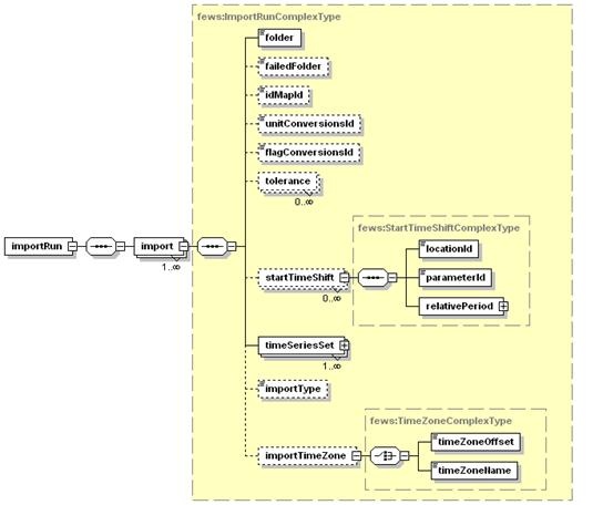
Figure 63 Elements of the EAImport configuration.