The OpenEarth philosophy related to data aims to collect and disseminate important data sets in a project-superseding manner rather than on a project-by-project basis.
This requires that all datasets are conform to a number of basic quality criteria:
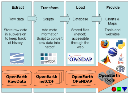
- data is not just numbers and meta-information, but consists of raw data produced by the measuring equipment (e.g. volts) + processing scripts.
- raw data should be stored in the OpenEarthRawData repository enabling version control
- raw data should then be enriched with metadata and processed into useful data products (netCDF) using transformation scripts also put under version control in a repository
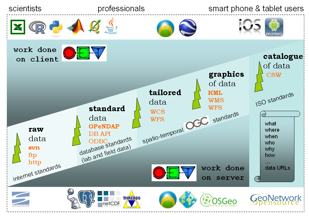
- resulting data products should conform to the best open source standards available
- data products should be made available easily via webbased interfaces (OPeNDAP) but also with automated procedures for widely-used data processing languages such as matlab, IDL, python, fortran, C and java (OpenEarth Tools)
- data products are primarily meant for dissemination, raw data and scripts are primarily meant for archiving
The data collection procedure and the relation between those standards is explained in the [OpenEarth Data Standards] document, developed in the framework of the EU FP7 Project MICORE. The basis the 3-step ETL procedure that is well-known in database world. ETL describes the process to Extract data from somewhere, Transform it to the strict database datamodel requirements, and Load it into the database. We extend ETL with one crucial extra step: provide the data to users via the web. We believe that any effective data management solution should include the user both at the start of the ETL process and and the end. Loading data into the database and using data from the database should be possible from the work environment of the user.
Numerous other datasets have been or are being uploaded continually in the MICORE and Building with Nature research programmes. And OpenEarth is not the only initiative to share and disseminate government-paid Earth science data freely on the web using open standards. We made an inventory of related initiatives. Our aim is to spread the use of the open standards and make them stick in our everyday work.
<object width="425" height="344"><param name="movie" value="http://www.youtube.com/v/7w2DBazX6g4&hl=en&fs=1"></param><param name="allowFullScreen" value="true"></param><param name="allowscriptaccess" value="always"></param><embed src="http://www.youtube.com/v/7w2DBazX6g4&hl=en&fs=1" type="application/x-shockwave-flash" allowscriptaccess="always" allowfullscreen="true" width="425" height="344"></embed></object>
| Unknown macro: {lozenge} OpenEarth data collection protocol |
| Unknown macro: {lozenge} Store your raw data here (Step 1) |
| Unknown macro: {lozenge} Access using OpenDAP protocol THREDDS |
| Unknown macro: {lozenge} Access using OpenDAP protocol THREDDS only |
| Unknown macro: {lozenge} Data in Google Earth |
| Unknown macro: {lozenge} Access data using the WMS and WFS services |
| Unknown macro: {lozenge} Meta-data with map overview data using the WCS services |