OpenEarth is one of the three nominees for the Dutch Data Award 2012 in the category exact and technical sciences!
This is the MathWorks presentation of the course held in Zoetermeer, the 26th of April.
Several techniques are explained to make Matlab running faster and handle large datasets. Unfortunately, for many of the applications described, Parallel Computing ToolBox is required.
If you have troubles with loading the file, visualize it here.
Visit http://www.mathworks.nl/ or contact giorgio.santinelli@deltares.nl for any further information.
Prior to the NCK days 2012 a sprint session is organized on web access to coastal data.
OpenEarth will showed this poster, and published this article in the NCK proceedings.
When: Tuesday 2012 march 13th
Time:
- 13:30 - sprintsesson
- 18:30 - optional dinner in mensa
- 20:00 - NCK icebreaker (building 44)
Where: TU Twente, Westhorst 217 (WH217) in bulding 22 (for entrance see red arrow on attached map, for car users we suggest parking lot P2).
Sign-up: Gerben.deBoer_at_deltares.nl
This announcement will be updated.
Please bring your own laptop and data
Cabled internet access is availbele, so please bring a UTP cable.
Thanks to OpenEarth and in collaboration with Rijkswaterstaat, the Kustlijnkaartenboek over the years (1992-2012) is now visible on Google Earth™.
Transects, BKL, TKL and trends are defined as in Rijkswaterstaat Kustlijnkaarten.
Files are available per coastal section at Kustlijnkaartenboek

Nationaal Modellen- Data en Centrum & OpenEarth on behalf of Building with Nature jointly organize two sprint sessions on live web access to data, version controlled tools and Google Earth feeds. The morning and afternoon sessions can be attended separately.
- when: Friday December 2nd, 10:00-16:00
- where: KNMI, Wilhelminalaan 10, de Bilt. route: www.knmi.nl/contact
- Sign-up: gerben.deboer<at>deltares.nl & plieger<at>knmi.nl
- !! Bring your own data and laptop !!
Friday December 2nd
- 09:30 - 10:00 coffee
- 10:00 - 12:00 Google Earth plotting
You will get a free account for OpenEarthTools which contains the open source GooglePlot toolbox for Matlab™. This allows you to plot any data directly into Google Earth™ using the KML standard. In addition we will discuss the OGC Web Mapping Service (WMS) standard for exchange of graphics over the web, which is also supported in Google Earth and GIS packages. Several WMS services will be demonstrated using the KNMI ADAGUC portal which serves spatio-temporal data (e.g. neerslagradar). - 12:00 - 13:00 lunch
- 13:00 - 16:00 OPeNDAP data cloud
How to use data from an OPeNDAP/netCDF data cloud with Matlab, Python and R. Deltares and KNMI have both OPeNDAP servers running with open data. Access to several datasets will be demonstrated during the session. We will install the required open source toolboxes and explore the available open data. A virtual machine image with OPeNDAP examples for R and python will be provided. In addition we will discuss and demonstrate the OGC Web Coverage Service (WCS) standard for exchange of gridded data products over the web. - 16:30 + drinks
In the framework of NMDC KNMI and Deltares jointly organize a workshop on OPeNDAP server-side aspects. This workshop is meant for both IT managers and data managers. The morning and afternoon sessions can be attended together or separately.
09:30 - 12:30: IT experts: hardware, OS, networks, safety
13:00 - 16:00: data managers: thredds configuration, meta-data standards, catalogs.
16:00 + drinks
where: tuesday Nov 29th
when: http://www.knmi.nl/contact/.
For more information please contact gerben.deboer<at>deltares.nl.
NRC Handelsblad front page news item: Dutch national science foundation NWO requires scientist to open up their data!
Wednesday Nov 2nd there will be a free sprint session on Matlab pre- and postprocessing of OpenDelft3D featuring a free hands-on training in plotting model results in Google Earth with OpenEarthTools GooglePlot toolbox. The DelftDashBoard and QuickPlot pre- and postprocessing GUI's will also be discussed.
Please sign up via: http://www.delftsoftwaredays.nl/index.php/register-for-the-delft-software-days-2011 and tick "Open Source Pre- and Postprocessing Workshop (free)".
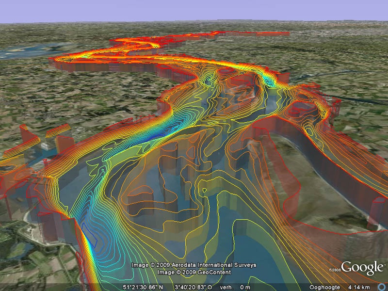
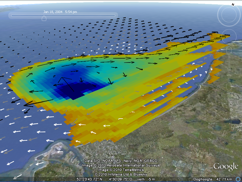
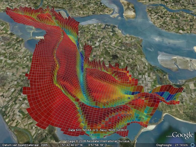
Join, bring your own laptop, your own Delft3D model schematisation
and view your own model as the Delft3D examples below.


|
|
Front page executive summary
|
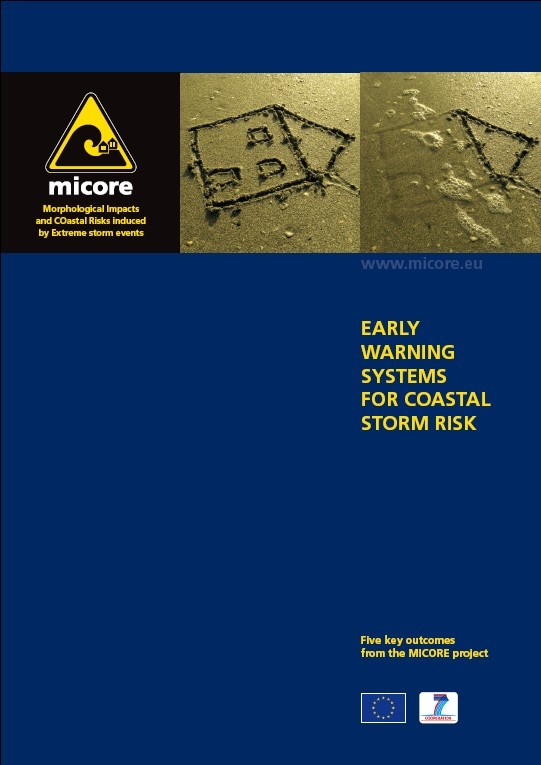
The EU FP7 project MICORE prepared an executive summary with the five main outcomes of the project. Among the key outcomes are:
- the successful use of OpenEarth as a protocol for data and knowledge sharing
- the use of the Frame of Reference approach as a means to build bridges between coastal experts and end-users
The English as well as the Dutch version may be downloaded below
See netCDF Operator (NCO) for a small example of the many possibilities of NCO!
In September OpenEarth will meet with DANS director Peter Doorn (http://www.dans.knaw.nl/) to exchange ideas on data archiving.
In the context of the EU challenge on valuable and interesting use of open public data, we submitted the visualisation below.
Load a bathymetric profile for the Western Scheldt, and you'll see this on Google Earth:

Neelie Kroes' open data challange May 16th en 17th
Nationaal Modellen- Data en Centrum & OpenEarth on behalf of Building with Nature jointly organize two sprint sessions on live web access to data, version controlled tools and Google Earth feeds. The morning and afternoon sessions can be attended separately.
- when: 2011 june 1st and 17th, 10-12 and/or 12-17
- where: Deltares, Rotterdamseweg 185, Delft. (route: www.deltares.nl)
- Sign-up: gerben.deboer@deltares.nl
- Bring your own laptop!!
Wednesday june 1st
- 09:30 - 10:00 coffee
- 10:00 - 12:00 SubVersion: Introduction to version control for data, models and tools. The concept will be introduced, we will install the TortoiseSVN client locally to download the free OpenEarthTools toolbox. Next we will learn how to upload tools and large raw data files to Subversion, and how to use it team wise.
- 12:00 - 13:00 lunch
- 13:00 - 16:00 OPeNDAP data cloud: How to use data from an OPeNDAP/netCDF data cloud with Matlab, Python or R. Deltares and KNMI have OPeNDAP server running with open data. We will install the required open source toolboxes and explore the available open data
- 16:30 + drinks
Friday june 17th
- 09:30 - 10:00 coffee
- 10:00 - 12:00 Matlab Google Earth plotting: You will get an account for OpenEarthTools which contains the open source GooglePlot toolbox for Matlab™. This allows you to plot any data directly and 3D into Google Earth™.
- 12:00 - 13:00 lunch
- 13:00 - 16:00 OPeNDAP data cloud (same as june 1st): How to use data from an OPeNDAP/netCDF data cloud with Matlab, Python or R. Deltares and KNMI have OPeNDAP server running with open data. We will install the required open source toolboxes and explore the available open data.
- 16:30 + drinks