On 19 April 2011 the Open Geospatial Consortium (OGC) has approved netCDF as a standard:
- http://www.opengeospatial.org/pressroom/pressreleases/1373
- http://www.unidata.ucar.edu/blogs/news/entry/open_geospatial_consortium_approves_netcdf
The netCDF library can be enabled with OPeNDAP, thereby allowing for easy remote "data cloud" access of large datasets. Please see thew following tutorial how to get started with using netCDF with OPeNDAP yourselves: http://public.deltares.nl/display/OET/web+overview+of+OPeNDAP+data

![]()
![]()
News items posted on the OpenEarth wiki are now automatically posted on the OpenEarth LinkedIn group:
http://www.linkedin.com/groups/OpenEarth-3746269
Join that group to stay informed and linked to other OpenEarth enthousiasts.
The IMBER secretariat (http://www.imber.info/index.html) has published the Data Management Cookbook, which is a very practical and informally written plea for datamanagement and personal data-responsiblity in a project team in sea going ocean sciences. If you replace 'cruise' by 'project' in the text, it holds for all projects we are dealing with.
Check it out: IMBER_cookbook_2011_Final.pdf
As of this friday (march 25) tests that were located in the trunk of the OpenEarthTools repository have been moved to a new test location (https://repos.deltares.nl/repos/OpenEarthTools/test/).
Developers are requested to store all tests and test data in the sub folders at this (test)location, to avoid contaminating our source code (trunk). The test dir can be checked out in the same way as the trunk, or even as one repos (when checking out the complete https://repos.deltares.nl/repos/OpenEarthTools/).
A small step for an OpenEarth developer, a great step for mankind: the whole suppletion database - the annual sand nourishment to keep the Dutch feet dry - on your smart phone (iphone).
Load this KML file yourselves to see this:


Disclaimer: we did not yet get kmz files working, nor local kml files, only kml links. And we found some issues when a kml links to other pngs. And the timespan does not work yet either. But at least we made a start.
Just before the NCK icebreaker (see NCK program) there will be an Openearth sprintsession at NIOZ, Texel, zie flyer.
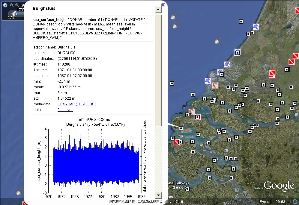
Have a look at all new Rijkswaterstaat timeseries in Google Earth: all pop-up boxes now contain a preview of timeseries and statistics. The kml overview is now generated with the catalog.nc meta-data created by the OET Matlab opendap crawler. OPeNDAP database has also been updated, now with more version history in each file.
- new kml on new kml server: http://kml.deltares.nl/kml/rijkswaterstaat/waterbase/
- updated netCDF OPeNDAP collection: http://opendap.deltares.nl/thredds/catalog/opendap/rijkswaterstaat/waterbase/
The mlabwrapper enables you to call Matlab functions from Python. Since compiling the wrapper is not a straightforward task, readily installable executables are provided for the matlab versions 2010a & 2010b. You have to install the wrapper in your python directory and, consequently, import the wrapper into python by calling "from mlabwrap import mlab". Every matlab function can then be called by mlab.matlabfunction (for example mlab.magic(10)). If you would like to compile the wrapper yourself (for example for another matlab version) some useful suggestions can be found here.
A new visualization demonstrating the activity in the OpenEarth Tools repository is available here
Fedor Baart gave a presentation about integrated modeling in the morphology discipline.
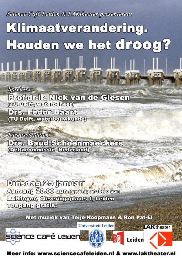
At the Sciencecafe Leiden Prof. dr. ir. Nick van de Giesen (TU Delft, waterbeheer) and Drs. Fedor Baart (TU Delft, waterbouwkunde) gave a presentation about Dutch river and coastal management. Drs. Baud Schoenmaeckers led the discussion.

A funny-but-also-serious article by freelance journalist Zeeya Merali on the common practice of scientific programming and what to do to make it more robust. http://public.deltares.nl/download/attachments/40731505/Merali_Nature2010.pdf
Source: googlegeodevelopers
Back in December of 2009, five leading scientists from the American Geophysical Union trekked to the remote Google office in downtown San Francisco. Lost until now, the video of their presentations have resurfaced. So, for the first time ever, we present, the Lost Archives of the Google Geo Developers Series
Jeffrey Cardille of Universitie de Montreal discusses GeoSearch, a new virtual globe application for the submission, storage, and sharing of point-based ecological data.
Thijs Damsma of Deltares discusses his use of KML to visualize coastal data.
Ross Beyer of NASA and SETI discusses his work visualizing Mars data and imagery using Google Earth.
Tyler Erickson of Michigan Tech Research Institute discusses his tools for to visualizing 4-D atmospheric carbon monitoring data using KML and Google Earth
Yaxing Wei of Oak Ridge National Lab discusses his Spatial Data Access Tool which enables visualization and access of geospatial data using OGC services and Google Earth.
Posted by Mano Marks, Geo APIs team
The OpenEarth OPeNDAP server opendap.deltares.nl will be out of service on tuesday dec 7th 2010 for maintenance.
From that day on a maintenance window will be scheduled every 1st tuesday of the month.
You can use the mirror at the 3TU when opendap.deltares.nl is not available (http://opendap.tudelft.nl/thredds/catalog/data2/deltares/catalog.html).