| Name | Size | Creator | Creation Date | Labels | Comment | ||
|---|---|---|---|---|---|---|---|
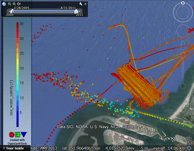
| PNG File ferrybox_salinity.nc_2011-08.png | 521 kB | Gerben J. de Boer | 16-03-2016 11:34 |
|
RIjkswaterstaat scanfish (meetvis) salinity data for one month | ||
| Version 1 (current) | 521 kB | Gerben J. de Boer | 16-03-2016 11:34 | RIjkswaterstaat scanfish (meetvis) salinity data for one month | |||
| JPEG File vaklodingen_haringvlietmonding[1].jpg | 81 kB | Reinier Schrijvershof | 05-11-2014 13:14 |
|
|||
| Version 2 (current) | 81 kB | Reinier Schrijvershof | 05-11-2014 13:14 | ||||
| Version 1 | 81 kB | Reinier Schrijvershof | 05-11-2014 13:14 | ||||
| JPEG File jerico_delft_summerschool_shoremonitoring03.jpg | 109 kB | Gerben de Boer | 23-06-2014 11:24 |
|
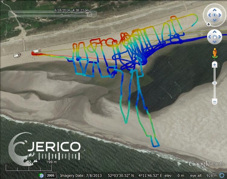
Beach and foreshore elevation of Sand engine gathered with DGPS on quad and wheel barrow during JERICO 2014 summerschool | ||
| Version 1 (current) | 109 kB | Gerben de Boer | 23-06-2014 11:24 | Beach and foreshore elevation of Sand engine gathered with DGPS on quad and wheel barrow during JERICO 2014 summerschool | |||
| JPEG File jerico_delft_summerschool_shoremonitoring02.jpg | 103 kB | Gerben de Boer | 23-06-2014 11:24 |
|
Beach and foreshore elevation of Sand engine gathered with DGPS on quad and wheel barrow during JERICO 2014 summerschool | ||
| Version 1 (current) | 103 kB | Gerben de Boer | 23-06-2014 11:24 | Beach and foreshore elevation of Sand engine gathered with DGPS on quad and wheel barrow during JERICO 2014 summerschool | |||
| JPEG File jerico_delft_summerschool_shoremonitoring01.jpg | 70 kB | Gerben de Boer | 23-06-2014 11:24 |
|
Beach and foreshore elevation of Sand engine gathered with DGPS on quad and wheel barrow during JERICO 2014 summerschool | ||
| Version 1 (current) | 70 kB | Gerben de Boer | 23-06-2014 11:24 | Beach and foreshore elevation of Sand engine gathered with DGPS on quad and wheel barrow during JERICO 2014 summerschool | |||
| JPEG File jerico_delft_summerschool_shoremonitoring04.jpg | 77 kB | Gerben de Boer | 23-06-2014 11:24 |
|
Beach and foreshore elevation of Sand engine gathered with DGPS on quad and wheel barrow during JERICO 2014 summerschool | ||
| Version 1 (current) | 77 kB | Gerben de Boer | 23-06-2014 11:24 | Beach and foreshore elevation of Sand engine gathered with DGPS on quad and wheel barrow during JERICO 2014 summerschool | |||
| PNG File ices_salt_2009_2010b.png | 820 kB | Gerben de Boer | 04-12-2013 23:10 |
|
ICES 2009 salinity obtained with OET tool getICESdata.m from SOAP service http://ocean.ices.dk/webservices/hydchem.asmx | ||
| Version 1 (current) | 820 kB | Gerben de Boer | 04-12-2013 23:10 | ICES 2009 salinity obtained with OET tool getICESdata.m from SOAP service http://ocean.ices.dk/webservices/hydchem.asmx | |||
| JPEG File mud_sedero_rate_WaddenSea_1985_2013_2.jpg | 164 kB | Arnold van Rooijen | 24-07-2013 10:24 |
|
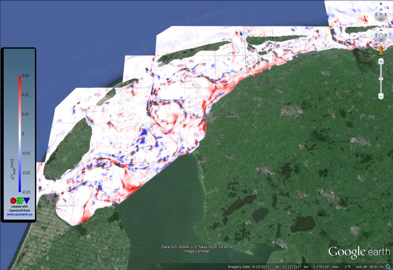
Sedimentation/erosion rate for mud (grain size < 63 mum) in the Wadden Sea based on vaklodingen 1985-2013 in combination with the sediment atlas (grain size) data. | ||
| Version 1 (current) | 164 kB | Arnold van Rooijen | 24-07-2013 10:24 | Sedimentation/erosion rate for mud (grain size < 63 mum) in the Wadden Sea based on vaklodingen 1985-2013 in combination with the sediment atlas (grain size) data. | |||
| JPEG File sedero_rate_WaddenSea_1985_2013_2.jpg | 157 kB | Arnold van Rooijen | 24-07-2013 10:21 |
|
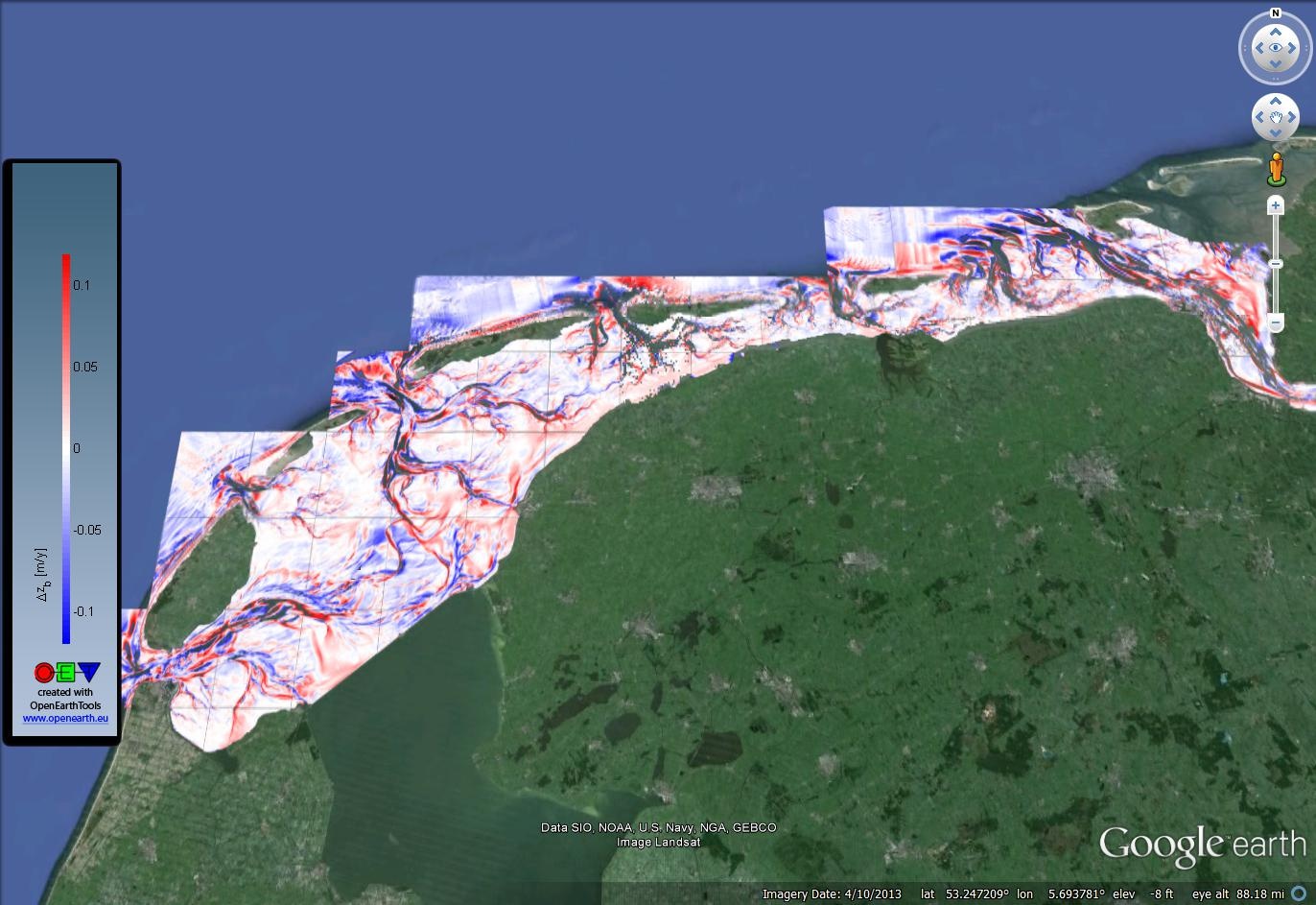
Sedimentation/erosion rate within the Wadden Sea based on the vaklodingen dataset 1985 to 2013. | ||
| Version 1 (current) | 157 kB | Arnold van Rooijen | 24-07-2013 10:21 | Sedimentation/erosion rate within the Wadden Sea based on the vaklodingen dataset 1985 to 2013. | |||
| JPEG File WaddenSea_Vakloding_MostRecent.jpg | 90 kB | Arnold van Rooijen | 23-07-2013 16:12 |
|
Wadden Sea most recent bathymetry based on 'Vaklodingen'-dataset. | ||
| Version 1 (current) | 90 kB | Arnold van Rooijen | 23-07-2013 16:12 | Wadden Sea most recent bathymetry based on 'Vaklodingen'-dataset. | |||
| PNG File sed_distr_and_mud_content_in_waddensea_incl_png.png | 422 kB | Gerben de Boer | 23-07-2013 15:52 |
|
sediment atlas waddenzee with grains zie disdistribution graphs | ||
| Version 1 (current) | 422 kB | Gerben de Boer | 23-07-2013 15:52 | sediment atlas waddenzee with grains zie disdistribution graphs | |||
| PNG File VOS.png | 742 kB | Gerben de Boer | 07-06-2013 11:48 |
|
Vessels of Opportunity temperature data | ||
| Version 1 (current) | 742 kB | Gerben de Boer | 07-06-2013 11:48 | Vessels of Opportunity temperature data | |||
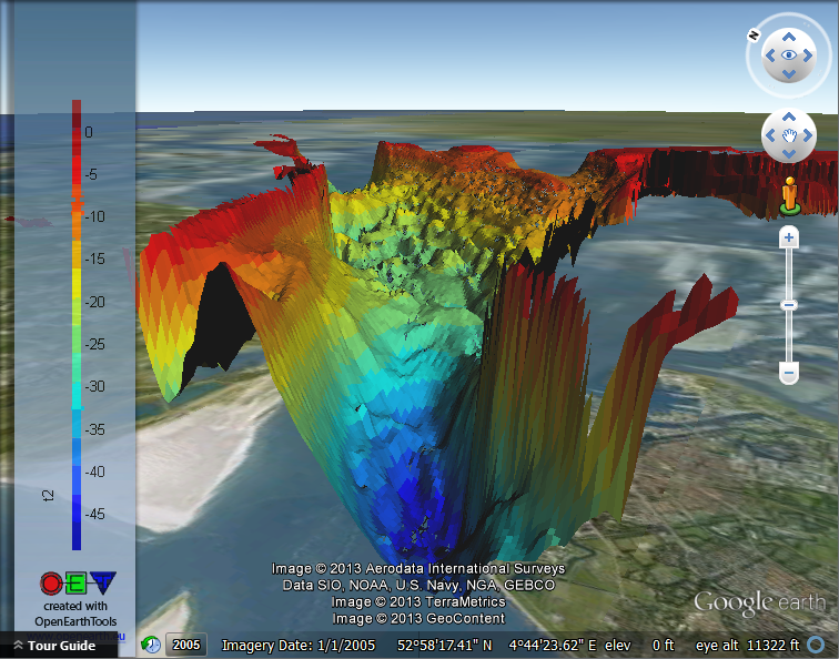
| PNG File vaklodingen_KB122_2120_3d.png | 430 kB | Gerben de Boer | 03-06-2013 11:21 |
|
vaklodingen tile KB122_2120 3D view created with KMLsurf.m | ||
| Version 1 (current) | 430 kB | Gerben de Boer | 03-06-2013 11:21 | vaklodingen tile KB122_2120 3D view created with KMLsurf.m | |||
| PNG File vaklodingen_KB122_2120_3d_topview.png | 510 kB | Gerben de Boer | 03-06-2013 11:21 |
|
vaklodingen tile KB122_2120 2D view created with KMLsurf.m | ||
| Version 1 (current) | 510 kB | Gerben de Boer | 03-06-2013 11:21 | vaklodingen tile KB122_2120 2D view created with KMLsurf.m | |||
| Multimedia File scotertjers.avi | 2.29 MB | Gerrit Hendriksen | 25-03-2013 08:04 |
|
Animation of observations of common scoters in Voordelta (PMR-NCV project Deltares) | ||
| Version 1 (current) | 2.29 MB | Gerrit Hendriksen | 25-03-2013 08:04 | Animation of observations of common scoters in Voordelta (PMR-NCV project Deltares) | |||
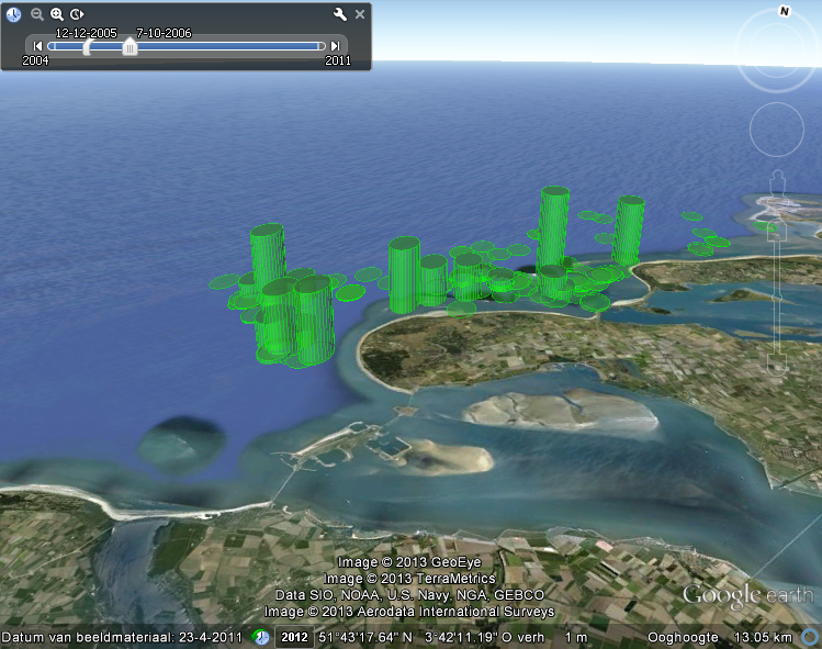
| PNG File kustviewer_eendjes.png | 732 kB | Gerrit Hendriksen | 25-03-2013 08:02 |
|
Observations of common scoters near Voordelta (PMR-NCV project Deltares) | ||
| Version 1 (current) | 732 kB | Gerrit Hendriksen | 25-03-2013 08:02 | Observations of common scoters near Voordelta (PMR-NCV project Deltares) | |||
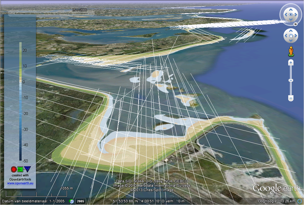
| PNG File kusthoogte_vlieglijnen_eems_dollard.png | 1.03 MB | Gerben de Boer | 15-01-2013 23:44 |
|
Rijkswaterstaat kusthoogte lidar data with its airplane tracks (Ems-Dollard) | ||
| Version 1 (current) | 1.03 MB | Gerben de Boer | 15-01-2013 23:44 | Rijkswaterstaat kusthoogte lidar data with its airplane tracks (Ems-Dollard) | |||
| PNG File kusthoogte_vlieglijnen_voordelta.png | 969 kB | Gerben de Boer | 15-01-2013 23:44 |
|
Rijkswaterstaat kusthoogte lidar data with its airplane tracks (Voordelta) | ||
| Version 1 (current) | 969 kB | Gerben de Boer | 15-01-2013 23:44 | Rijkswaterstaat kusthoogte lidar data with its airplane tracks (Voordelta) | |||
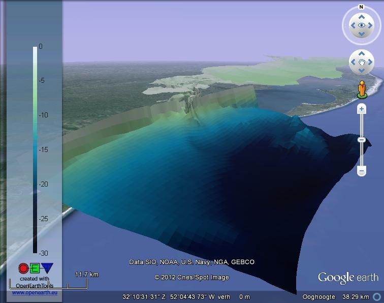
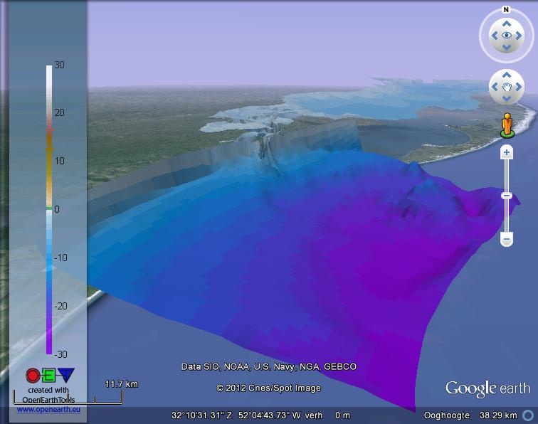
| JPEG File patos_lagoon_GMT_ocean.jpg | 44 kB | Gerben de Boer | 07-12-2012 12:56 |
|
Delft3D model of Patos Lagoon (Brazil) plotted with colormap "GMT_ocean". Model is part of OpenearthModels. | ||
| Version 1 (current) | 44 kB | Gerben de Boer | 07-12-2012 12:56 | Delft3D model of Patos Lagoon (Brazil) plotted with colormap "GMT_ocean". Model is part of OpenearthModels. | |||
| JPEG File patos_lagoon_GMT_globe.jpg | 43 kB | Gerben de Boer | 07-12-2012 12:56 |
|
Delft3D model of Patos Lagoon (Brazil) plotted with colormap "GMT_globe". Model is part of OpenearthModels. | ||
| Version 1 (current) | 43 kB | Gerben de Boer | 07-12-2012 12:56 | Delft3D model of Patos Lagoon (Brazil) plotted with colormap "GMT_globe". Model is part of OpenearthModels. |
![vaklodingen_haringvlietmonding[1].jpg](/download/attachments/42401924/vaklodingen_haringvlietmonding%5B1%5D.jpg?api=v2)