Summary
The TKI project “Development of a Groundwater Information System” involved the development, testing and improvement of both the hardware and software components of an autonomous electrical geophysical monitoring system. The parties involved are Subsurface Insights LLC (SSI, Hanover, USA) and Deltares (Delft, the Netherlands).
Within the scope of this TKI, Deltares provided in-house expertise for the development and testing of the system. Development-wise, Deltares was involved with the design and optimization of the system’s hardware and especially the electronics. Moreover, input for handling of the product during the field-testing phase was provided to deduce which components were working as expected. Deltares also granted access for the system to be tested during some of its projects.
This TKI project’s deliverable is a data acquisition and information delivery system which enables the long-term monitoring of groundwater-related phenomena using raw geo-electrical, DTS (Distributed Temperature Sensing using fibre optic cables) and weather measurements, accessible to the end users at any time. The main objective is to develop a new system in a way which allows easier installation, operation, data processing and delivery of processed information to its users. Such a system should therefore be cost-efficient and provide information in a format which can be digested by non-domain experts and be accessible online.
The TKI allowed Subsurface Insights and Deltares to have a deeper understanding of the necessary steps required to make electrical geophysical monitoring possible. During the TKI, numerous versions of the hardware and software components of the system were tested as part of multiple projects (both for Deltares and other parties), and the lessons learned were used to improve the system’s design. The main knowledge developed during this TKI is that it is possible to monitor subsurface processes in the field in an automated manner.
Motivation
Timely and affordable information about the spatial and temporal behavior of groundwater, as well as its quality and quantity is of critical importance to policy makers and stakeholders in (amongst others) the agricultural sector, the (drinking)water sector and for site remediation. The value of such information about the subsurface is necessary for applications such as:
- Effective storage and use of water in the subsoil,
- Monitoring possible saltwater intrusion along the coast,
- Pumping fresh water from the subsoil,
- Verification of the behavior of aquifer thermal energy systems,
- Soil remediation effects,
- Behavior and position of injected liquids.
Out of the numerous geophysical methods which are able to generate this type of information, time-lapse electrical geophysics has proven to be among the most cost-effective, both in academic studies and in industry applications. Its widespread use has been driven by the relative ease with which data can be collected over large distances and over finely-sampled time intervals. In addition, this method enables the monitoring of physical processes occurring at a specific site for a prolonged amount of time.
As a result, both hardware and software enabling the measurement of electrical geophysical properties and their subsequent processing is becoming increasingly available commercially. At the same time, time-lapse electrical geophysics has broadened its scope from traditional geophysics to a wider array of applications. This in turn means that the insights from electrical geophysical data are now being leveraged by non-geophysicists, for example the agricultural sector, water managers, policy makers and land remediators, who have a need for actionable information compared to raw data.
A system with the ability to autonomously acquire such data, process them and deliver them in a way which is comprehensible to a wider audience would permit deeper insights to be leveraged by time-lapse electrical geophysics and from groundwater phenomena.
Time-lapse Electrical Geophysics
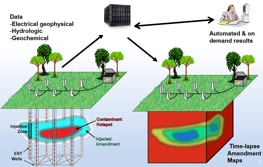
Electrical geophysical methods (such as Direct Current (DC) resistivity, induced polarization and self-potential) aim to measure and map the spatial distribution of subsurface electrical properties. These properties are a function of (among others) soil type, fluid chemistry and fluid saturation and temperature. Changes in these properties can be indicative of processes such as salt-water intrusion or mineral precipitation/dissolution. By conducting electrical geophysical measurements over successive time intervals at the same location using an identical experimental configuration (acquisition geometry and equipment), the spatial and temporal change in these properties can be monitored. Time-lapse electrical geophysical data can therefore provide monitoring information on subsurface processes, following its acquisition, processing and interpretation.
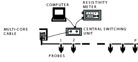
A typical acquisition system for DC (Direct Current) resistivity measurements consists of a resistivity meter, an electric source (battery), cables with electrodes (metal rods placed in the ground), a switching box and a control and storage unit (computer). For each measurement, two current electrodes (A,B) are used: one to inject the current into the subsurface and the other to retrieve the injected current. The electric field is measured with two other electrodes, called the potential electrodes (M,N). The way in which the current and potential electrodes are arranged on the Earth's surface is called an array. By changing the array’s configuration, the electrical properties of the subsurface are mapped.


Design of the Groundwater Information System (GIS)
Most of the system’s components were developed under this TKI through numerous development iterations. The development process started from testing the latest version, evaluating that design during field tests and identifying problems, solving those problems and re-designing the system accordingly. This process was repeated until a satisfactory version of the system was running for the specific application it was being tested upon. The system in question consists of the following components:
- Data acquisition components
- Electrical geophysical instrumentation
- Water tension meters
- Weather stations
- Cyber-infrastructure, accessible both through a web interface and through software APIs
- Acquisition and processing control
- Autonomous data collection and ingestion
- QA/QC management components (to validate and store information)
- Software for data processing, visualization and reporting
- System health information with user notifications
- Cloud hosted relational database for data storage and access/delivery
- A smartphone app which empowers the user to control or change the measurement cycle and visualize measurements
- Website
Testing of the GIS: Jurong island, Signapore
Project Background
While the system was also tested as part of other Deltares projects, the most extensive testing was performed during this project, for which the system had to deliver information. The aim of the project was to locate and evaluate groundwater reserves on Jurong island, an artificial/reclaimed island in Singapore. Due to the aquifer on Jurong island being a managed aquifer, the interface between fresh and saltwater is affected by both natural (rainfall, evapotranspiration, tidal effects) and anthropogenic processes (artificial recharge and extraction). The research conducted aimed to strengthen the understanding of the Jurong aquifer’s natural behavior and the impact of artificial recharge and extraction on the development of a freshwater lens. The role of the GIS system in this project was to enrich the available field monitoring data on Jurong island and improve and validate conceptual and numerical aquifer models from a previous project.
Field Setup
Three locations were monitored in total. Solar panels that charged car batteries provided electricity on all sites for the measurement units. These measurement units controlled, amongst others, the measurement protocols and data transfer. For each horizontal resistivity line, the electrodes were installed 2m below the cable to ensure lower contact resistivity due to their closer proximity to the groundwater.


Several challenges arose during the monitoring program on Jurong island. Among these, lightning, fire, overgrowth of trees and re-installation of cables to deeper depths delayed the acquisition and showcased some faults in the system. Regular maintenance, system updates and reparis were all necessary throughout the project.
Results
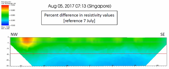
The time-lapse electrical resistivity system allowed for the qualitative characterization of hydrological processes in Jurong Island. Both raw and processed data showed the reaction of the system to experiments and natural processes as well as the recovery of the system to a base state. At one of these two sites, the electrical resistivity data showed a gradual decrease in resistivity around and below the fresh-saltwater boundary with time, indicating the that saltwater intrusion was occurring in that zone. On the other hand, drying was observed in the top layers, shown by a general increase in resistivity values, correlating well with the months during which rainfall was reduced.

Outlook
The Groundwater Information System developed as part of this TKI is a monitoring system for the long-term monitoring of groundwater related phenomena. The integration of data acquisition and information delivery through an online cyber-infrastructure which can control both the operation of the system’s data collection as well as the storage, processing and dissemination of results and measurements is a novel concept. The system’s web interface provides updates on system status, allows data access and visualization of results online. This enables monitoring, where data needs to be processed as fast as it is being collected (Figure 12). In addition, the end user can interact with the system more easily through the cloud-based software architecture. By automating all aspects of resistivity monitoring, the tools that have been created can provide information when it is needed and can thus act as a warning system.
The TKI allowed Subsurface Insights and Deltares to have a deeper understanding of the necessary steps required to make electrical geophysical monitoring possible. During the TKI, numerous versions of the hardware and software components of the system were tested as part of multiple projects (both for Deltares and other parties), and the lessons learned were used to improve the system’s design.
As a result, the main knowledge developed during this TKI is that it is possible to monitor subsurface processes in the field in an automated manner. A particular application that this system is more suitable and has been tested for is monitoring the fresh-saltwater interface in the subsurface, processing the data and presenting the results in a way that the end user can visualize any changes in this boundary on their phone and being notified via an alarm when the boundary is too high, allowing for quicker reactions.
More information on the current status of the system can be found on: www.subsurfaceinsights.com