...
Two methods of interpolation are available;
Serial interpolation
In serial interpolation mode, interpolation is done to fill any gaps in a time series. The interpolation module will only consider the time series itself in filling these gaps. Interpolation methods that can be used are;
- Filling of gaps with a default value
- Filling of gaps by linear interpolation
- Filling of gaps by block interpolation
- Extrapolation of gaps at start or end of a time series
All these methods can be configured to only fill gaps that are not more than of a given duration. Essential to the understanding of the Interpolation module is that the module does not have the capability to identify gaps due to potentially unreliable data in a time series. It will only provide an alternative value for those data points of which the quality flag is set to Unreliable. The validation module can be configured to identify unreliable data and set quality flags as appropriate.
Spatial Interpolation
In spatial interpolation mode, the interpolation can be either applied to fill gaps in time series, or to create a new time series for a location using data from other (spatially distributed) locations. Spatial interpolation can also be applied for sampling scalar time series from grid time series, for re-sampling grids, or for creating grids from time series data. Different methods of spatial interpolation are available;
...

Figure 54 Root element of the interpolation module configuration
interpolationSet
Root element for the definition of an interpolation step. Multiple entries may exist.
Attributes;
- interploationId interpolationId : Id of the interpolation defined. Used for reference purposes only. This Id will be included in log messages generated.
serialInterpolation
Root element for the definition of serial interpolation options.
spatialInterpolation
Root element for the definition of spatial interpolation options.
timeSeriesInputSet
Input time series set. Note that when the interpolation module is used to fill gaps in time series the input time series set is the same as the output time series set. The time series sets may include either a single location or a locationSet. Note that the latter may not always be possible when using the "default" interpolation option, as the default may be location specific.
...
Output time series set. Note that when the interpolation module is used to fill gaps in time series the input time series set is the same as the output time series set. Identification is only required when the series generation option is used in spatial interpolation. The locations defined in this timeSeriesSet, and their geographical attributes, determine the locations of the series generated.
| Anchor | ||||
|---|---|---|---|---|
|
| Anchor | ||||
|---|---|---|---|---|
|
...

Figure 55 Elements for defining serial interpolation options in the Interpolation module configuration.
serialInterpolationOption
...
Maximum gap length of unreliable data in seconds which will be filled using the interpolation option defined. If the gap is longer, then none of the values will be replaced.
defaultValue
Default value to use to replace interpolation values.
| Anchor | ||||
|---|---|---|---|---|
|
| Anchor | ||||
|---|---|---|---|---|
|
...
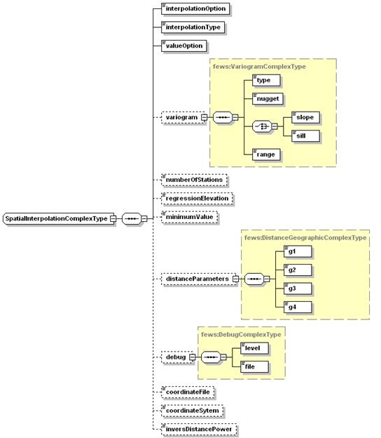
Figure 56 Elements for defining spatial interpolation options in the Interpolation module configuration.
interpolationOption
Selection of type of spatial interpolation. Enumeration of available options is;
- inversedistance ; for inverse distance weighted interpolation between available values at spatially distributed locations.
- bilinear ; for bilinear interpolation between available values at spatially distributed locations.
- kriging ; for interpolation using Kriging between available values at spatially distributed locations.
- gridcellaveraging; for interpolation of time series based on averaging grid cells (used for example for establishing catchment averages where the catchment size is much larger than the grid cell size).
- Closest distance; for interpolation of time series based on the closest distance between available values at spatially distributed locations. An extra option is to interpolate from a grid to a longitudinal profile.
interpolationType
Specify if spatial interpolation is used for filling gaps in series or for generating a new series. Note in the latter case the output variable will need to be defined. This also defines if the output variable is a grid time series or a scalar time series. The available options are:
- seriesfilling: for filling gaps in time series (scalar timeseries only).
- seriesgeneration: for creating a new time series.
valueOption
Option to determine how input values are used. Enumeration of available options is;
...
Root element for the semi-variogram to be used when Kriging is applied.
variogram:type
Type of variogram to be used. Enumeration of available options is;
...
 is the correlation coefficient, and
  the distance between parameter pairs.
variogram:nugget
Nugget of the variogram
variogram:slope
Slope of the variogram. Used for linear variogram types.
variogram:sill
Sill of the variogram.
variogram:range
Range of the variogram.
numberOfStations
Number of stations to consider in spatial interpolation. Used in Inverse distance when taking a limited number of stations into account. The nearest stations will be used in preference.
regressionElevation
Elevation level at which the regression split is applied.
minimumValue
Minimum value of the output data. For interpolation of rainfall data this should be set to zero. Numerically the interpolation may produce invalid (negative) data.
distanceParameters
Distance parameters for computing actual distances between locations when projection is geographical (WGS1984). Four parameters are required.
debug
Optional debug level. Spatial interpolation is implemented through a DLL. This can produce a log file, depending on level specified. A setting of 1 is the lowest level, a setting of 4 is highest (can produce very extensive log files).
coordinateFile
Coordinate file allocating grid cells to be considered per location. This coordinate file follows a specific format. Locations to be interpolated to are indicated through their spatial location. After each location a list of grid cells (m,n coordinates) to be considered is included.

coordinateSystem
Indicates if coordinate system is longitude-latitude this is defined as 1. If not 0 is used and distances are calculated in metres.
inverseDistancePower
Power applied to the inverse distance interpolation.