...
| Issue type | Detailed issue | Location | Illustration |
|---|---|---|---|
| Temporal change; managed realignment | As a result of recent managed realignment, the foreshore is not recognized correctly and wave attenuation is not calculated over the present foreshore. Reasons: 1-The global coastline still follows the former (now outer) levee instead of the present levee. 2-The intertidal elevation map was made using images spanning multiple years; if the intervention occurred after this period, or caused ambiguous values, the area is not included in the map. If the area is not inundated regularly, the intertidal map cannot represent the elevation correctly, and the viewer reverts to using inaccurate SRTM topography. Solution: If this type of area is of interest, apply request application of the Expert Advanced functionality that can incorporate any DEM, to the site. For an example of what results are possible, have a look at one of the FAST Study sites. | Freiston, UK |  |
| Temporal change or data quality | The viewer does not display the vegetation cover as observed by the eye of the user. Reasons: 1-The vegetation has established recently before the period used to construct the vegetation presence/absence map. 2-Part of the vegetation was covered by clouds and/or water during the period used for the construction of the vegetation presence/absence map. Solution: Apply Request application of the Expert Advanced functionality to the site, using recent and suitable Sentinel imagery for a site-specific vegetation cover. For an example of what results are possible, have a look at one of the FAST Study sites. | Freiston, UK |  |
| Complex topography; unclear coastline | Although the orientation of the transect in the viewer is correct, the resulting wave attenuation should be regarded with considerable caution: the algorithms in the viewer are made for a single water-land transition. Solution: Apply Request application of the Expert Advanced functionality to the site , defining dedicated transects with output at meaningful locations and process-based calculations that can deal with complex topography. For an example of what results are possible, have a look at one of the FAST Study sites. | Blakeney, UK | 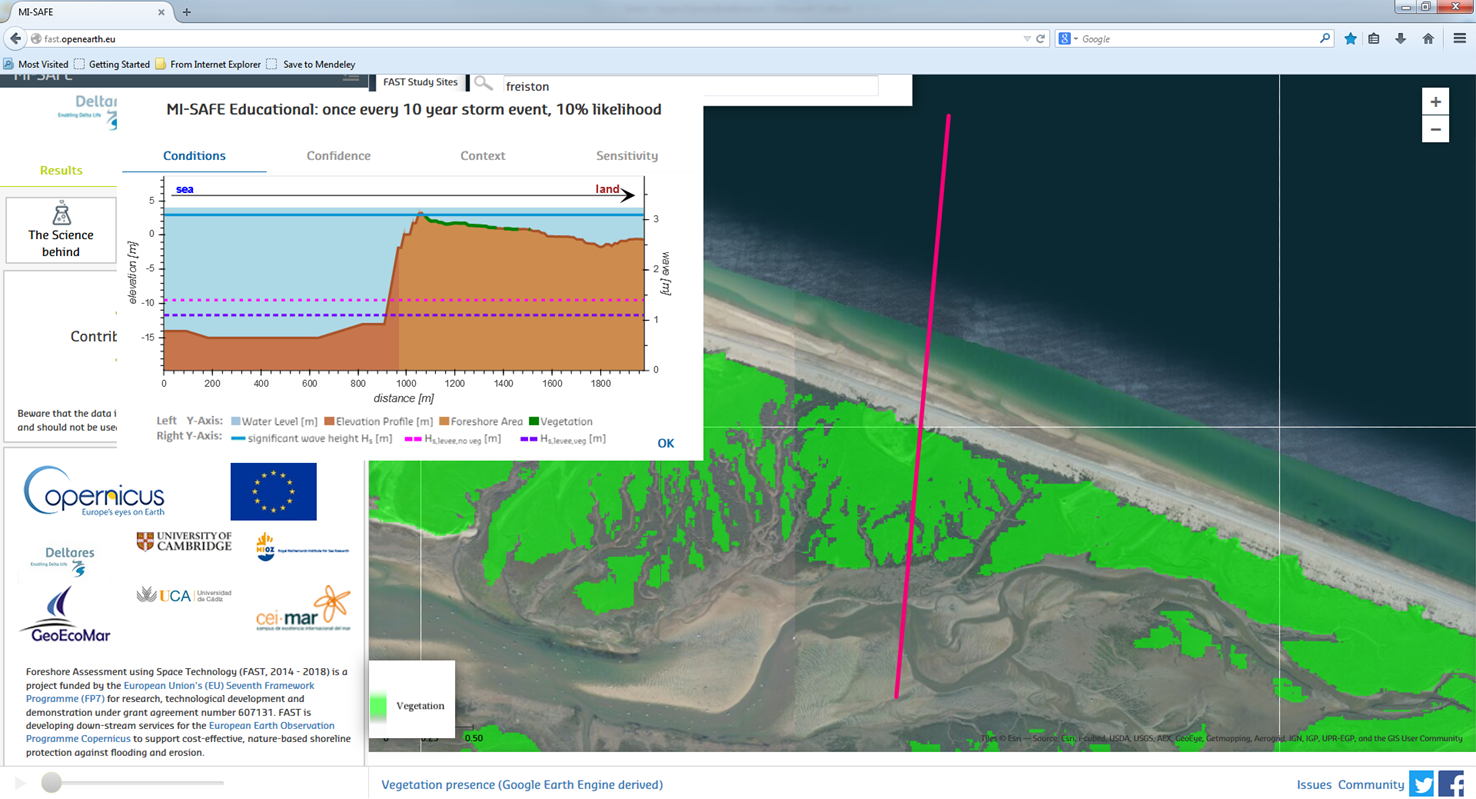 |
| Incorrect land elevation | The Sundarbans are a very low-lying area; land elevations around +10 MSL do typically not occur. The reason for the high observed elevation is that the SRTM topography used the reflection of the top of the mangrove canopy. Likewise, the intertidal elevation map cannot display this sort of area correctly, as waterlines underneath the canopy are not visible. | Sundarbans, Bangladesh | 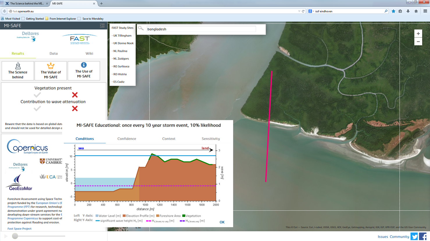 |
| Incorrect bathymetry | On some locations, the edges, i.e. the area near land, of the GEBCO bathymetry appear to be substantially deeper than the offshore areas. From other, not globally available bathymetry products such as EMODNET, we know that this is not true. Solution: On most locations the issue is cosmetic because the use of the intertidal elevation map provides a correct bathymetry where it matters; the calculations are meaningful but the transect looks strange. In the Expert Advanced functionality, detailed bathymetric data can be used to ensure a correct transformation from offshore to nearshore waves. For an example of what results are possible, have a look at one of the FAST Study sites. | Bradwell-on-Sea, UK |  |
The case study sites
...