...
For every timeatep, this transformation will query the locations that have a value. Locations where the current value is missing, will be ignored. Using the selected stations a network of Thiessen polygons is calculated. Each polygon is given the value of the related location. In the next processing step, the polygons are overlayed on the output locationSet. This can be polygons (eg subcatchments), but also a grid and scalar locations.
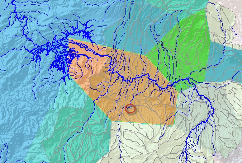
The location at the circle has a value for this timestep and accordinaly a Thiessen polygon is calculated for this station |
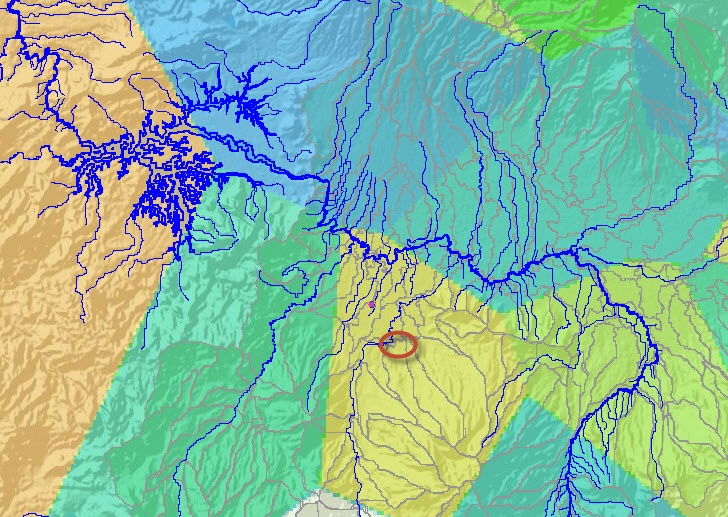
in this timestep there is no value for the station, and thus the Thiessen polygons are only drawn for the stations with values |
|---|
Output
- outputVariable (data for polygons)
Configuration example
| Code Block | ||
|---|---|---|
| ||
<?xml version="1.0" encoding="UTF-8"?>
<transformationModule version="1.0" xmlns="http://www.wldelft.nl/fews" xmlns:xsi="http://www.w3.org/2001/XMLSchema-instance" xsi:schemaLocation="http://www.wldelft.nl/fews http://fews.wldelft.nl/schemas/version1.0/transformationModule.xsd">
	<!--rainfall-->
	<variable>
		<variableId>Rain_Gauge</variableId>
		<timeSeriesSet>
			<moduleInstanceId>ImportTelemetry</moduleInstanceId>
			<valueType>scalar</valueType>
			<parameterId>P.obs</parameterId>
			<locationSetId>precipitation</locationSetId>
			<timeSeriesType>external historical</timeSeriesType>
			<timeStep id="daily0930"/>
			<relativeViewPeriod unit="day" start="-10" end="0" startOverrulable="true"/>
			<readWriteMode>read only</readWriteMode>
		</timeSeriesSet>
	</variable>
	<variable>
		<variableId>Rain_Basin</variableId>
		<timeSeriesSet>
			<moduleInstanceId>HEC_HMS_Sittoung_Update_Pre</moduleInstanceId>
			<valueType>scalar</valueType>
			<parameterId>P.sim</parameterId>
			<locationSetId>SubBasin</locationSetId>
			<timeSeriesType>simulated historical</timeSeriesType>
			<timeStep id="daily0930"/>
			<relativeViewPeriod unit="day" start="-10" end="0" startOverrulable="true"/>
			<readWriteMode>add originals</readWriteMode>
			<!--<delay unit="minute" multiplier="30"/>-->
		</timeSeriesSet>
	</variable>
	<transformation id="SpatialInterpolation_Rain">
		<interpolationSpatial>
			<thiessenPolygon>
				<inputVariable>
					<variableId>Rain_Gauge</variableId>
				</inputVariable>
				<distanceGeoDatum>UTM46N</distanceGeoDatum>
				<outputVariable>
					<variableId>Rain_Basin</variableId>
				</outputVariable>
			</thiessenPolygon>
		</interpolationSpatial>
	</transformation>
</transformationModule> |
...