...
Returns a pi timeseries xml file containing the timeseries data from a grid cell for a request period. The grid is specified by passing a layerId. The grid cell is determined by specifying a x and y coordinate and a bounding box. Currenly only EPSG:3857 is supported for the x,y, and bounding box coordinates. At least a layer, startTime, endTime, x,y and bounding box are required.
Request parameters
- bbox (string): bounding box of map that is viewed in , separated EPSG:3857 format. The order of the coordinates is as follows: bottom left X, bottom left Y, top right X, top right Y. For example:
bbox=-1558755.612890017,4979850.04379049,1623657.8112034467,6709422.556884765 - convertDatum (boolean): Convert values from relative location height to absolute height values.
- documentVersion (string, 1.9 or up): File format version (optional). For example: 1.23
- documentFormat (string): PI_XML (default) or PI_JSON
- elevation (double): used for 3d data, like for example water depth, to get the timeseries of a grid point at a specific elevation.
- endTime (dateTime: yyyy-MM-ddTHH:mm:ssZ, required): End time of search period that looks for timeseries values that lie within this period.
- layers (string, required): layerd id (currently only one layer is supported and required) that matches the gridPlot id as configured in the gridDisplay. Every gridPlot that has been configured in the grid display configuration represents a WMS layer. For more information, see the WMS Service documentation: FEWS Web Mapping Service with time support (WMS-T)
- externalForecastTime (dateTime format: yyyy-MM-ddTHH:mm:ssZ): Time value of external forecast time.
- ensembleId (String): Used in combination with ensembleMemberId to identify a unique ensemble. Since 2020.01.
- ensembleMemberId (String): Used in combination with ensembleId to identify a unique ensemble. Since 2020.01.ensemble. Since 2020.01.
- importFromExternalDataSource (boolean, default true): import data from external data source (Archive). (since 2019.02)
- layers (string, required): layerd id (only one layer is supported and required) that matches the gridPlot id as configured in the gridDisplay. Every gridPlot that has been configured in the grid display configuration represents a WMS layer. For more information, see the WMS Service documentation: FEWS Web Mapping Service with time support (WMS-T)
- omitMissing (boolean): Toggle omitting or returning of missing values in response
- onlyHeaders (boolean): Toggle to return only header information or also data
- onlyForecasts (boolean): Toggle to return only forecast timeSeries
- onlyManualEdits (boolean): Toggle to return only manual edits.
- showProducts (boolean): Toggle to display product information that is assigned to a forecast. (Since 2019.02). See below for an example.
- showStatistics (boolean): Toggle to return statistics information about timeseries. Typically used in combination with onlyHeaders. Returns additional information about data availability of timeseries (Since 2015.01).
- firstValueTime: First time with a value in the timeSeries
- lastValueTime: Last time with a value in the timeSeries
- maxValue: Maximum value in the timeSeries
- minValue: Minimum value in the timeSeries
- valueCount: Number of values in the timeSeries
- showThresholds (boolean): Option to toggle the returning of threshold information in the headers
- showEnsembleMemberIds (boolean): Show ensemble member ids.
- showVerticalProfile (boolean): Show vertical profile in case of 3D data.
- startTime (dateTime: yyyy-MM-ddTHH:mm:ssZ, required): Start time of search period that looks for timeseries values that lie within this period.
- thinning (long): unit ms/pixel. Thinning is used to retrieve the visually interesting time steps of timeSeries. It tries to keep the peaks and gaps and minimizes the number of time steps that have to be retrieved. It is typically used for visualizations. The value to be specified should be equal to the view period in milliseconds of the timeSeries that is visualized divided by the number of pixels that are available for display. For example: visualizing a view period of 5 years (157784760000 milliseconds) on a display of 1024 pixels, the thinning parameter should be set to 157784760000/1024 = 15408668. (Since 2019.02)
- useMilliseconds (boolean) Optional argument. Default is false. If it is set to true, the response will contain milliseconds. See example below. Since 2019.02startTime (dateTime: yyyy-MM-ddTHH:mm:ssZ, required): Start time of search period that looks for timeseries values that lie within this period.
- useDisplayUnits (boolean): Export values using display units.
- importFromExternalDataSource (boolean, default true): import data from external data source (Archive). (since 2019.02)
- x (double, required): x postion on the map in EPSG:3857 format.
- y (double, required): y postion on the map in EPSG:3857 format.bbox (string): bounding box of map that is viewed in , separated EPSG:3857 format. The order of the coordinates is as follows: bottom left X, bottom left Y, top right X, top right Y. For example:
bbox=-1558755.612890017,4979850.04379049,1623657.8112034467,6709422.556884765
Response
- Timeseries PI-XML or PI-JSON file content.
...
This timeSeries grid functionality can also be tested using the WMS service test page. Right clicking on a grid cell, will show a popup that will show the value of the grid cell for the current time step. When clicking on the PI Service URL the PI Request that was used to determine the current value, will be opened.

Example PI-XML and JSON response
...
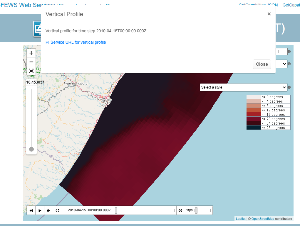
For 3D grids the elevation parameter can be used to get the timeseries of a grid cell at a specified elevation (for example to get the water temperature at a specific water depth). On the WMS testing page this functionality can be tested by right clicking on a grid cell. The vertical slider on the left can be used to specify the elevation that should be used. When selecting the "Grid time series" option, a popup with the PI service URL will be generated that will get the timeseries for a grid cell at the selected elevation.

An example request with elevation:
...
It is also possible to get a vertical profile for 3D data. On the WMS testing page this functionality can be tested by right clicking on a grid cell. When selecting the "Vertical Profile" option, a popup with the PI service URL will be generated that will get the timeseries of all elevations for a grid cell at the selected timestep. This is achieved by passing the showVerticalProfile=true parameter. It is possible to request vertical profiles for more than one time step by using the startTime and endTime.
An example request to get the vertical profile for one time step:
...