| Table of Contents |
|---|

 This project has received funding from the European Union’s Seventh Framework Programme for research, technological development and demonstration under grant agreement no 607131.
| Table of Contents |
|---|
The value of MI-SAFE
What is MI-SAFE?
...
The MI-SAFE package includes an accessible set of products and services accessible and demonstrated through a user-friendly online viewer: the MI-SAFE viewer.
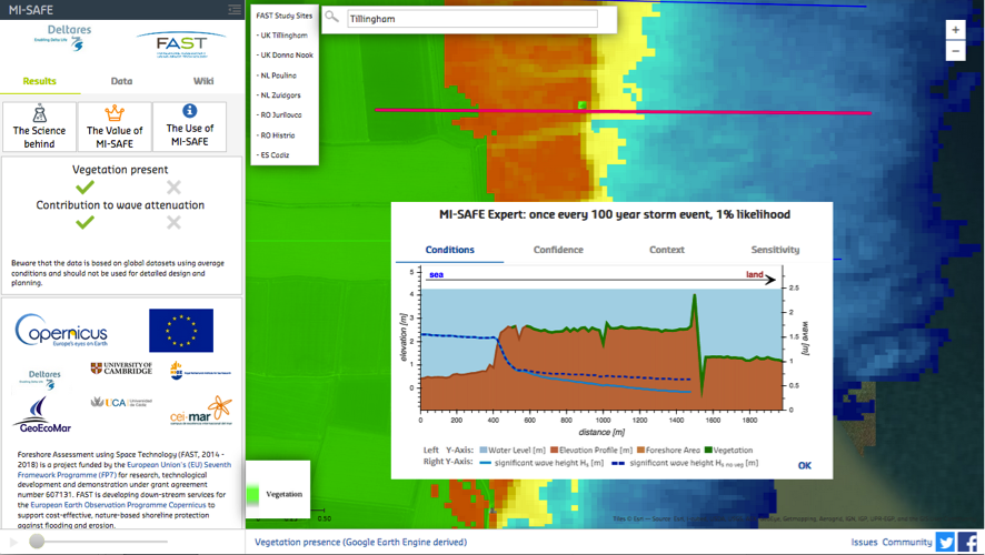
Figure 1. Screen shot of MI-SAFE viewer showing an example of Expert level services for one FAST study site: Tillingham saltmarsh (UK).
...
To generate this information, FAST has gathered, reclassified and produced open format layers of geographical information; using Earth Observation resources (e.g. Sentinel satellite images), and data collected in situ by the FAST team. These layers, together with the intensive scientific fieldwork that underpins FAST, have been used to establish relationships between elevation, vegetation properties, water level and wave dynamics. Those relationships have been used to calibrate the open software wave model XBeach and thus to estimate the effects of foreshore vegetation on wave attenuation and sea wall overtopping. For further technical and scientific details on MI-SAFE products and services see the public link 'the Science behind MI-SAFE'.

Figure 2. Summary of the MI-SAFE package. The MI-SAFE viewer is a key element to access the Educational (blue), Expert (brown) as well as the Advanced level services (green). The logos of the team of experts supporting MI-SAFE are included.
...
Our global scale products are available for sites that differ from the FAST study cases, using online global maps of water depth, elevation, and vegetation coverage derived from space-borne sensors, and with wave and storm surge conditions derived from global ocean models.

Figure 3. Example of MI-SAFE Educational level service. Combination of elevation, tidal range, wave height and vegetation presence layers to estimate areas where foreshore vegetation has a potential contribution to reduce flood risk in Europe. All these layers are available via the Global Base maps of the MI-SAFE viewer at the MI-SAFE GeoNetwork CSW catalogue.
...
As examples of Advanced level services, FAST has combined products and services with those generated by the EU project RISC-KIT to estimate the risk of overtopping (XBeach, FAST) and the corresponding flooding (LISFLOOD, RISC-KIT) for our Tillingham study site (UK) (Figure 4). These examples are available in the MI-SAFE viewer for the Tillingham study site.
 A)
A)
...
 B)
B)
...
 C)
C)
...
Figure 4. A) Combination of FAST (XBeach-VEG) and RISC-KIT (LISFLOOD) elements used to generate an advanced service modelling overtopping and inundation due to the impact of a large storm on a vegetated foreshore. B) XBeach 3D non-hydrostatic model of impact of a large storm at Tillingham saltmarsh (UK). C) LISFLOOD simulation of inundation impact of a large storm at Tillingham saltmarsh (UK).
...