Log in
Linked Applications
Loading…
Spaces
Hit enter to search
Help
Online Help
Keyboard Shortcuts
Feed Builder
What’s new
Available Gadgets
About Confluence
Log in
OpenEarth
Pages
Blog
Space shortcuts
How-to articles
Browse pages
Configure
Space tools
Space Tools
search
attachments
weblink
advanced
Overview
Content Tools
Overview
Content Tools
Browse Pages
Undefined Pages
Attachments
RSS Feeds
Filter By File Extension:
Filter By Label:
Name
Size
Creator
Creation Date
Last Modification Date
Labels
Attached To
PNG File
image2016-9-19 14:21:31.png
470 kB
Ale Ferrara
19-09-2016 14:21
19-09-2016 14:21
No labels
Page:
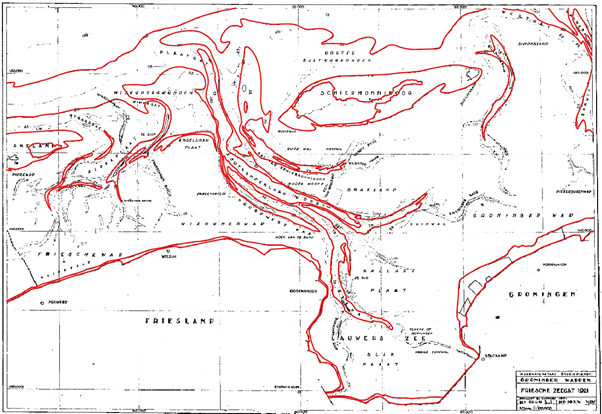
Vaklodingen Interpolated Dataset
PNG File
image2016-9-16 16:54:29.png
141 kB
Ale Ferrara
16-09-2016 16:54
16-09-2016 16:59
No labels
Page:
Convert bathymetric scanned maps in shapefile with QGIS
PNG File
image2016-9-16 16:54:49.png
61 kB
Ale Ferrara
16-09-2016 16:54
16-09-2016 16:59
No labels
Page:
Convert bathymetric scanned maps in shapefile with QGIS
PNG File
image2016-9-16 16:55:7.png
9 kB
Ale Ferrara
16-09-2016 16:55
16-09-2016 16:59
No labels
Page:
Convert bathymetric scanned maps in shapefile with QGIS
PNG File
image2016-9-16 16:55:26.png
200 kB
Ale Ferrara
16-09-2016 16:55
16-09-2016 16:59
No labels
Page:
Convert bathymetric scanned maps in shapefile with QGIS
PNG File
image2016-9-16 16:55:57.png
67 kB
Ale Ferrara
16-09-2016 16:55
16-09-2016 16:59
No labels
Page:
Convert bathymetric scanned maps in shapefile with QGIS
PNG File
image2016-9-16 16:56:19.png
84 kB
Ale Ferrara
16-09-2016 16:56
16-09-2016 16:59
No labels
Page:
Convert bathymetric scanned maps in shapefile with QGIS
File
delftdashboard_v2.01.12629.7z
26.43 MB
Kees Nederhoff
26-07-2016 13:30
26-07-2016 13:30
No labels
Page:
Delft Dashboard (DDB)
ZIP Archive
DelftDashboard_r12761_160622.zip
35.21 MB
Kees Nederhoff
26-07-2016 10:45
26-07-2016 10:45
No labels
Page:
Delft Dashboard (DDB)
PNG File
image2016-7-21 11:32:43.png
60 kB
Ale Ferrara
21-07-2016 11:32
21-07-2016 11:32
No labels
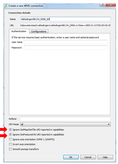
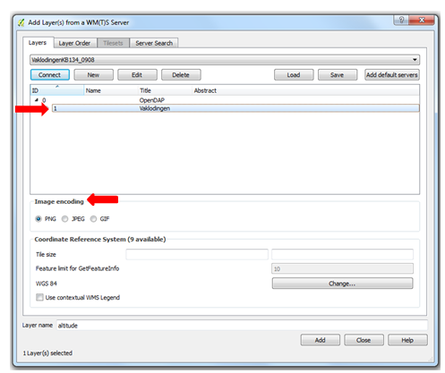
Page:
Open Vaklodingen data in QGIS via OPeNDAP WMS service
PNG File
image2016-7-21 11:30:42.png
72 kB
Ale Ferrara
21-07-2016 11:30
21-07-2016 11:30
No labels
Page:
Open Vaklodingen data in QGIS via OPeNDAP WMS service
PNG File
image2016-7-21 11:30:22.png
74 kB
Ale Ferrara
21-07-2016 11:30
21-07-2016 11:30
No labels
Page:
Open Vaklodingen data in QGIS via OPeNDAP WMS service
PNG File
image2016-7-21 11:29:36.png
68 kB
Ale Ferrara
21-07-2016 11:29
21-07-2016 11:29
No labels
Page:
Open Vaklodingen data in QGIS via OPeNDAP WMS service
PNG File
image2016-7-21 11:29:17.png
60 kB
Ale Ferrara
21-07-2016 11:29
21-07-2016 11:29
No labels
Page:
Open Vaklodingen data in QGIS via OPeNDAP WMS service
PNG File
image2016-7-21 11:28:50.png
62 kB
Ale Ferrara
21-07-2016 11:28
21-07-2016 11:28
No labels
Page:
Open Vaklodingen data in QGIS via OPeNDAP WMS service
PNG File
image2016-7-21 11:27:50.png
59 kB
Ale Ferrara
21-07-2016 11:27
21-07-2016 11:27
No labels
Page:
Open Vaklodingen data in QGIS via OPeNDAP WMS service
PNG File
image2016-7-21 11:27:35.png
44 kB
Ale Ferrara
21-07-2016 11:27
21-07-2016 11:27
No labels
Page:
Open Vaklodingen data in QGIS via OPeNDAP WMS service
PNG File
image2016-7-21 11:27:10.png
72 kB
Ale Ferrara
21-07-2016 11:27
21-07-2016 11:27
No labels
Page:
Open Vaklodingen data in QGIS via OPeNDAP WMS service
PNG File
azerwis_geoserver.png
20 kB
Gerrit Hendriksen
18-07-2016 08:39
18-07-2016 08:43
No labels
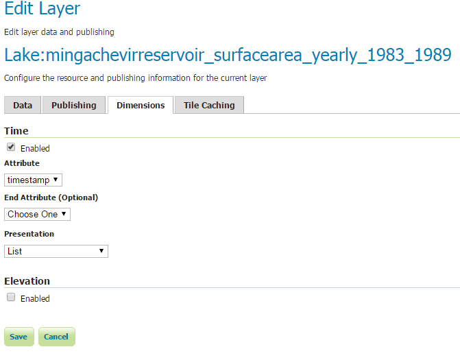
Page:
Adding time enabled layers to Geoserver
PNG File
Science-Geography-icon.png
1 kB
Gerben J. de Boer
13-07-2016 16:51
13-07-2016 16:51
No labels
Home page:
OpenEarth
Prev
1
2
3
4
5
6
7
8
9
10
11
12
13
…
54
Next
{"serverDuration": 75, "requestCorrelationId": "a812c186c8f3f6c7"}