H1330 - Atlantic salt meadows
General
General characteristics |
|
|---|---|
Common name |
Atlantic salt meadows |
Region |
The Netherlands |
Water system |
Transitional waters |
Nature parameter |
Habitat types |
HR nr |
H1330 |
Fact sheet by |
M. Haasnoot |
Description habitat
This habitat types includes salt marshes outside the dikes, which are regularly inundated by salt water, and areas inside the dike influenced by salt water. Characteristic species for this habitat type are Sea lavender (Limonium vulgare), Common saltmarsh grass (Puccinellia maritima), Sea-purslane (Atriplex portulacoides) and Couch grass (Elytrigia atherica).
General Occurrence
In The Netherlands, this habitat type can be found in de Wadden Sea and the Delta region. It used to occur on many places along the coast of the former Zuider Zee #1.
Environmental conditions
This habitat type can be found in a zone near the mean high water level up to the foot of low dunes and dikes, with a regular to incidental flooding frequency. This vegetation type prefers a salty environment and can be found in salt or brackish environments with a chloride concentration above 5gCl/L (#3, #4, #5.
Control and growth opportunities
Grazing is prosperous for the development of this habitat.
Dose-effect relations
Flowchart
Dose-effect relations
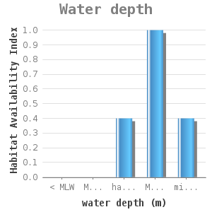
|
HAI |
|---|---|
< MLW |
0 |
MLW - half tide |
0 |
half tide - GHW |
0.4 |
MHW - midway MHWS |
1 |
midway MHWS - MHWS |
0.4 |
MLW = mean low water
MHW = mean high water
MHWS = spring tide high water
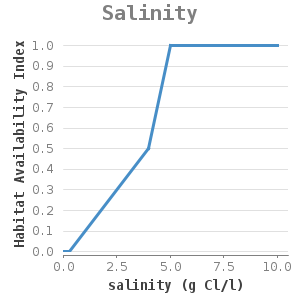
|
HAI |
|---|---|
0 |
0 |
0.3 |
0 |
4 |
0.5 |
5 |
1 |
10 |
1 |
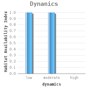
|
HAI |
|---|---|
low |
1 |
moderate |
1 |
high |
0 |
Dynamics has not been qualified, for instances in terms of velocity or wave height. This should be studied further in a project.
Uncertainty and validation
These dose-effect relations have been validated on a limited scale. This habitat type was used for the environmental impact assessment of the Volkerak Zoommeer. A qualitative comparison was made between the results of the current situation and ecotope maps. The results have been applied to this area.
Applicability
The relations are applicable to all transitional waters.
Example project
These relations have been used in the Krammer-Volkerak and Zoommeer projects #2.
References
1 http://www.minlnv.nl/natura2000
2 Haasnoot, M. en K.E. van de Wolfshaar (ed). (2006). Habitat analyse in het kader van de Planstudie/MER voor Krammer, Volkerak en Zoommeer. WL report Q4015
3 Hansson Ecodata. Calibratie van het model EMOE voor de vegetatie van de voordelta van het Haringvliet. Freiburg, 2005.
4 Schaminée, J.H.J., Weeda, E.J. en Westhoff, V. (1998). De vegetatie van Nederland. Deel 4. Plantengemeenschappen van de kust en van binnenlandse pioniermilieus. Opulus Press, Uppsala-Leiden.
5 Van der Meulen, Y.A.M.. Meren Ecotopen Stelsel. RIZA nota 97.076. 1997
6 Weeda, E.J., J.H.J. Schaminee, L. van Duuren (2003). Atlas van Plantengemeenschappen in Nederland. Deel3 Kust en binnenlandse pioniermilieus. KNNV Uitgeverij.