H3270 - Rivers with muddy banks with Chenopodion rubri pp and Bidention pp vegetation
General
General characteristics |
|
|---|---|
Common name |
Rivers with muddy banks with Chenopodion rubri pp and Bidention pp vegetation |
Region |
The Netherlands |
Water systems |
Flowing waters |
Nature parameter |
Habitat type |
HR nr |
H3270 |
Fact sheet by |
H. Coops |
Description habitat
General occurrence
The habitat type Rivers with muddy banks is characterised by the presence of pioneer vegetation of the Bidons alliances (Association of Red goosefoot and Pale persicaria 29 Aa3 and the Water mudwort association 29Aa4). These species prefer nitrogenous banks and sprout on banks, which are periodically dry. In a short period of time, they flower and produce seed. This vegetation can be found on sandy and muddy banks and on gravel banks along the branches of the River Rhine and Meuse. Mud flats and banks in the freshwater tidal zone (Oude Maas, Lek, Haringvliet, Biesbosch) are sometimes also included in this habitat type. The habitat is wide spread along larger rivers in low-lying areas and on European hills.
Characteristic species are Red goosefoot (Chenopodium rubrum), Marsh dock (Rumex palustris), Golden dock (Rumex maritimus), Pale persicaria (Persicaria lapathifolia), Spreading cinquefoil (Potentilla supina), Devil's beggarticks (Bidens frondosa), Three-lobe beggarticks (Bidens tripartita). Species of the assocation Water mudwort, which prefer a silty substrate, include Water mudwort (Limosella aquatica), Small Fleabane (Pulicaria vulgaris) and Brown galingale (Cyperus fuscus).
Environmental conditions
The habitat Rivers with muddy banks with Chenopodion rubri pp and Bidention pp vegetation can be found on young river banks with hardly any vegetation. The area it covers is mostly small and linear.
Because of a sharply varying presence of bare substrate, abundant after a period of erosive events and almost none after a number of low dynamic years, the area this habitat covers is in some years very restricted while in other years it can cover large parts of river banks. Vegetation growth strongly depends on the variable water levels in the summer period. This habitat and its characteristic species can be abundant in wet areas of river foreland where excavation took place for the benefit of river measures or nature development.
The soil type varies from sandy to very silty, with a domination of various vegetation types. Along the river Grensmaas, the habitat type is represented by low-lying gravel banks.
The development of this habitat is optimal a number of years after the development of a sand or gravel bank, before higher vegetation occurs. This habitat is regularly found in very dynamic, regenerating environments, such as low lying sandy beaches, but it will not flourish if water levels are unfavourable. When large bare surfaces are created for the benefit of nature development, his habitat can also be found. In case of grazing and churning of the soil, this habitat can further develop locally.
For some plants, the chance of occurrence depends on the seed supplies.
Control and growth opportunities
Construction of nature development areas, grazing.
Dose-effect relations
Flow chart
Dose-effect relations
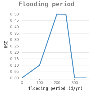
flooding period (d/jr) |
HSI |
|---|---|
0 |
0 |
100 |
0.1 |
200 |
0.5 |
250 |
0.5 |
300 |
0 |
365 |
0 |
Flooding period: the association of muddy riverbanks occur in zones with a high inundation frequency. #1 presents the ranges of the flooding period of plant communications in floodplains, indicating the potential occurrence of this type of vegetation. Actual occurrence and development depend on the water level conditions of the year involved.
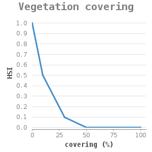
covering (%) |
HSI |
|---|---|
0 |
1 |
10 |
0.5 |
30 |
0.1 |
50 |
0 |
100 |
0 |
Vegetation covering: pioneer vegetation can be found on bare soils under favourable conditions, but it cannot develop in a closed cover. If vegetation already occurs on a potential location, because of former conditions, the chance of occurrence of muddy bank associations #2 reduces.
Uncertainty and validation
![]() These dose-effect relations have not been validated.
These dose-effect relations have not been validated.
Applicability
Banks of large rivers. It must be verified if the dose-effect relations can be applied to gravel banks without adjustments.
Example project
At present, there is no example of a project available.
References
1 Van de Steeg et al ....
2 Expert Judgement H. Coops