H6430 - Hydrophilous tall herb fringe communities of plains and of the montane to alpine levels
General
General characteristics |
|
|---|---|
Common Name |
Hydrophilous tall herb fringe communities of plains and of the montane to alpine levels |
Region |
Europe |
Water system |
Rivers and streams |
Nature parameter |
Habitat types |
HR nr |
H6430 |
Fact sheet by |
M. Haasnoot |
Description habitat
General occurrence
This habitat type H6430 is divided in type H6430A and H6430B.
Habitat type H6430A is defined as Hydrophilous tall herb fringe communities of plains and of the montane to alpine levels.
This habitat is typically found on riverbanks, streams and ditches and desolate, humid grass lands. Characteristic species for this vegetation type are Longleaf speedwell and Marsh spurge. This vegetation type transfers rapidly into brush or swamp forest.
Habitat type H6430B is defined as hydrophilous tall herb fringe communities of plains and of the montane to alpine levels type B. This type occurs on the boundaries of low brackish to almost fresh waters, in marshes and freshwater tidal areas. Characteristic species are Marsh sow thistle, Marsh mallow and Common scurvy grass. This habitat is mostly found in The Netherlands. Some occurring species are becoming endangered, for instance because of the absence of tidal influence #1.
Environmental conditions
The groundwater level is below surface level. The zone in which this type occurs floods rarely if ever. The habitat type is influenced by fresh water that has a chloride concentration of less than 0.25gCl/L (#3, #4, #2, #5). It occurs near the mean water line and is regularly flooded. The salt content referred to in literature, differs per sub community, but if the content exceeds 5gCl/L (#3 no community of this type occurs.
Control and growth opportunities
The most important control measurements are doing nothing or mowing incidentally.
Dose-effect relations
The dose-effect relations for habitat type H6430 have been divided in two sub type relations H6430A and H6430B as they have different habitat factors. Together, the suitable areas represent the area of H6430.
Flow chart
Dose-effect relations
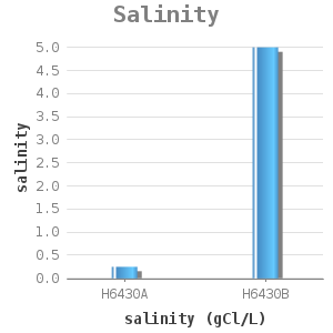
habitat type |
salinity (gCl/L) |
|---|---|
H6430A |
< 0.25 |
H6430B |
< 5.0 |
The habitat availability equals 1 if it complies with the above mentioned condition.
Reference: #1
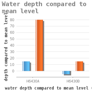
habitat type |
minimum depth (cm) |
maximum depth (cm) |
|---|---|---|
H6430A |
+ 15 |
+ 80 |
H6430B |
-5 |
+ 15 |
In the zone between minimum and maximum depth the habitat availability is 1.
Reference: #1
Uncertainty and validation
For the EIA Volkerak Zoommeer #1, these dose effect relations have been compared with measurement data. They are considered to be of sufficient quality to be applied.
Applicability
These dose-effect relations apply to banks of fresh as well as brackish waters. For the suitability of this habitat type, the maximum suitability of the two subtypes must be included. Together they comprise the type H6430.
Example project
The dose-effect relations have been used in #1.
References
1 Haasnoot, M. en K.E. van de Wolfshaar (ed). Habitat analyse in het kader van de Planstudie/MER voor Krammer, Volkerak en Zoommeer. WL report Q4015. 2006
2 Van der Meulen, Y.A.M.. Meren Ecotopen Stelsel. RIZA nota 97.076. 1997.
3 Hansson Ecodata. Calibratie van het model EMOE voor de vegetatie van de voordelta van het Haringvliet.
Freiburg, 2005.
4 Janssen, J.A.M. en Schaminée, J.H.J.. Europese natuur in Nedeland; Habitattypen. KNNV Uitgeverij Utrecht.
2003.
5 Schaminée, J.H.J., Weeda, E.J. en Westhoff, V.. De vegetatie van Nederland. Deel 4. Plantengemeenschappen
van de kust en van binnenlandse pioniermilieus. Opulus Press, Uppsala-Leiden. 1998.