...
Use 'zMapLayerNAme' for the average elevation, and zBottomMapLayerName and zTopMapLayerName in case a model layer needs to be defined.
Irregular grids
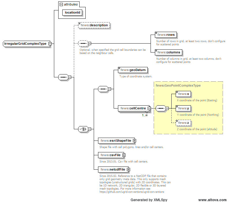

Figure 30 Elements of the irregular grid in the Grids configuration
...
Optional description of the grid. Used only for reference purposes
rows, columns
Optional, when specified the grid cell boundaries can be based on the neighbour cells. Number of rows and columns in the gridgrid, at least two rows and two columns. Don't configure this for scattered point grids.
geoDatum
Coordinate system the grid is defined in. This may be a different coordinate system to that used in the main map display. The coordinate system may also differ per grid. A grid may be regular in one coordinate system, but may be irregular in another. Defining the grid in the regular coordinate system is generally easier.
...
Geographic coordinates of the ell cell centre point (x: Easting, y: Northing).
cellCentre: z
Elevation of the cell centre point.
esriShapeFile
Shape file with cell polygons, lines and/or cell centers.
csvFile
Since 2013.01. Csv file with cell centers.
netcdfFile
Since 2015.02. Reference to a NetCDF file that contains only grid geometry meta data. This only supports mesh topologies (unstructured grids) with 2D coordinates. This can be 1D network, 2D triangular, 2D flexible or 3D layered mesh topologies. For more information see https://github.
...
com/ugrid-conventions/ugrid-conventions
Irregular grid definition from a UGRID NetCDF file
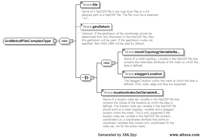
file
Name of a NetCDF file in the map layer files or a full absolute path to a NetCDF file. The file must have extension ".nc".
geoDatum
Optional. If the geoDatum of the coordinates cannot be determined from the infromation in the NetCDF file, then this geoDatum will be used. If this geoDatum is also not specified, then WGS 1984 will be used by default.
meshTopologyVariableName
Name of a mesh topology variable in the NetCDF file that contains the meta-data attributes of the mesh on which the data is defined.
staggerLocation
The (stagger) location within the mesh at which the data is defined. Only node, edge and face are supported.
locationIndexSetVariableName
Name of a location index set variable in the NetCDF file that contains the indices of the locations at which the data is defined. The location index set variable in the NetCDF file should point to a mesh topology variable and a (stagger) location within the mesh. This is only supported if the location index set variable in the NetCDF file contains coordinates (i.e. a coordinates attribute that points to coordinate variables that contain only coordinates for the index set, not for the entire mesh).
Config Examples
| Code Block | ||
|---|---|---|
| ||
<irregular locationId="meshLocation">
	<netcdfFile>
		<file>simplebox_hex7_map.nc</file>
		<meshTopologyVariableName>mesh2d</meshTopologyVariableName>
		<staggerLocation>face</staggerLocation>
	</netcdfFile>
</irregular> |
| Code Block | ||||
|---|---|---|---|---|
| ||||
<irregular locationId="Swan2D_G2_cellcenters"> <rows>1318</rows> <columns>317</columns> <esriShapeFile> <file>swan2D_G2_cellcenters.shp</file> <geoDatum>WGS 1984</geoDatum> <x>%X%</x> <y>%Y%</y> </esriShapeFile> </irregular> |
...
| Code Block | ||||
|---|---|---|---|---|
| ||||
<regular locationId="QPF"> <description>QPF Grid for ABRFC</description> <rows>159</rows> <columns>335</columns> <polarStereographic> <originLatitude>90.0</originLatitude> <originLongitude>-105.0</originLongitude> <scaleAtOrigin>0.933</scaleAtOrigin> <equatorRadius>6367470.0</equatorRadius> <poleRadius>6367470.0</poleRadius> </polarStereographic> <gridCorners> <geoDatum>WGS 1984</geoDatum> <upperLeft> <x>-106.67471389477944</x> <y>39.37455858318055</y> <z>0.0</z> </upperLeft> <lowerRight> <x>-92.34455929643786</x> <y>32.390342856654044</y> <z>0.0</z> </lowerRight> </gridCorners> </regular> |
Generate
Generating XML
For NetCDF and GRIB files you can generate the grids.xml with F12>Clipboard>Copy grib geometry form file