| Wiki Markup |
|---|
{scrollbar} |
Introduction to secondary validation SpatialHomogeneityCheck
Overwrites the flag of the timeseries with unreliable or doubtful when the estimation of the value based on neighbouring values differs too much from the observed value. The criteria for that can be specified to be a maximum threshold or relative (i.e. percentage of the standard deviation) or both. The estimation is based upon a maximum number of closest by other locations within a maximum search radius.
The purpose of this check is to update the flags of the output timeseries whenever the error exceeds the specified threshold. The error is defined by the difference between the value and the estimation which is the average of the values from the selected neighbouring locations weighted for distance. Note that the check suppports non-equidistant comparison where timesteps should be within the same fixed range +/- 500 milliseconds.
...
The estimation formula used:

where:
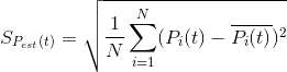
Pest(t) is the estimated value at the test station at time t
Pi(t) is the measured value at neighbour station i at time t
Di is the distance between the test station and the neighbour station i
N is the number of neighbour stations taken into account
b is the power of distance D, (default b=2)
Test criteria
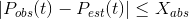
The test criterion with an absolute threshold is exceeded when the following condition fails:
The test criterion with relative threshold is exceeded when the following condition fails:

with:
b the admissable absolute difference
Xrel the multiplier of the standard deviation
SPest(t)
the standard deviation of neighbouring values
| Note | ||
|---|---|---|
| ||
Current implementation does not directly use the output time series in calculating the error. Instead to obtain the observed value Pobs it looks at the input time series for the same location as the output time series. This is because it enables changing the flag of a time series with different parameters / units compared to the input. In order for this to work correctly, the locations / location set of the input and output time series must be the same. |
Configuration
- id: identifier of the check.
- variableDefinition: embedded variable definition (see above).
- inputVariableId: One or more identifiers for variables of which the flags have to be used.
- outputVariableId: One or more identifiers for variables for which the flags have to be modified.
- searchRadius: The maximum radius for selecting reference locations in meters.
...
For each threshold,
- absolute or relative (or both since 2019.02) Compares theshold with absolute value, or relative factor times the standard deviation.
- appliesWhenWeightedNeighbors (since 2019.02) choose whether the weighted neighbors should be higher, lower or higherOrLower
- outputFlag: Output flag for values of output variables that exceed the specified threshold. (unreliable or doubtful)
- outputMode: When this option is set to logs_only, the flags will not be updated but the log events will be generated.
- sourceId: Fine grained id for indicating which check caused the flag to be altered. In this case these sourceIds must be specified in the regionConfig (CustomFlagSources.xml).
- logLevel: Log level for the log message that is logged if a time series does not pass the check. Can be DEBUG, INFO, WARN, ERROR or FATAL. If level is error or fatal, then the module will stop running after logging the first log message. Fatal should never be used actually.
- logEventCode: Event code for the log message that is logged if a time series does not pass the check. This event code has to contain a dot, e.g. "TimeSeries.Check", because the log message is only visible to the master controller if the event code contains a dot.
- logMessage: Log message that is logged if a time series does not pass the check. Some more options are available than in the other checks:
...
A configuration example for the spatialHomogeneityCheck is given below:
| Code Block | ||
|---|---|---|
| ||
<?xml version="1.0" encoding="UTF-8"?> <secondaryValidation xmlns="http://www.wldelft.nl/fews" xmlns:xsi="http://www.w3.org/2001/XMLSchema-instance" xsi:schemaLocation="http://www.wldelft.nl/fews http://fews.wldelft.nl/schemas/version1.0/secondaryValidation.xsd"> <variableDefinition> <variableId>spatialHomogeneityCheck_location1</variableId> <timeSeriesSet> <moduleInstanceId>SpatialHomogeneityCheck</moduleInstanceId> <valueType>scalar</valueType> <parameterId>H.obs</parameterId> <locationId>location1</locationId> <timeSeriesType>external historical</timeSeriesType> <timeStep unit="minute" multiplier="15"/> <readWriteMode>read complete forecast</readWriteMode> </timeSeriesSet> </variableDefinition> <variableDefinition> <variableId>spatialHomogeneityCheck_location2</variableId> <timeSeriesSet> <moduleInstanceId>SpatialHomogeneityCheck</moduleInstanceId> <valueType>scalar</valueType> <parameterId>H.obs</parameterId> <locationId>location2</locationId> <timeSeriesType>external historical</timeSeriesType> <timeStep unit="minute" multiplier="15"/> <readWriteMode>read complete forecast</readWriteMode> </timeSeriesSet> </variableDefinition> <variableDefinition> <variableId>spatialHomogeneityCheck_location3</variableId> <timeSeriesSet> <moduleInstanceId>SpatialHomogeneityCheck</moduleInstanceId> <valueType>scalar</valueType> <parameterId>H.obs</parameterId> <locationId>location3</locationId> <timeSeriesType>external historical</timeSeriesType> <timeStep unit="minute" multiplier="15"/> <readWriteMode>read complete forecast</readWriteMode> </timeSeriesSet> </variableDefinition> <variableDefinition> <variableId>spatialHomogeneityCheck_location4</variableId> <timeSeriesSet> <moduleInstanceId>SpatialHomogeneityCheck</moduleInstanceId> <valueType>scalar</valueType> <parameterId>H.obs</parameterId> <locationId>location4</locationId> <timeSeriesType>external historical</timeSeriesType> <timeStep unit="minute" multiplier="15"/> <readWriteMode>read complete forecast</readWriteMode> </timeSeriesSet> </variableDefinition> <variableDefinition> <variableId>spatialHomogeneityCheck_location5</variableId> <timeSeriesSet> <moduleInstanceId>SpatialHomogeneityCheck</moduleInstanceId> <valueType>scalar</valueType> <parameterId>H.obs</parameterId> <locationId>location5</locationId> <timeSeriesType>external historical</timeSeriesType> <timeStep unit="minute" multiplier="15"/> <readWriteMode>read complete forecast</readWriteMode> </timeSeriesSet> </variableDefinition> <variableDefinition> <variableId>spatialHomogeneityCheck_location6</variableId> <timeSeriesSet> <moduleInstanceId>SpatialHomogeneityCheck</moduleInstanceId> <valueType>scalar</valueType> <parameterId>H.obs</parameterId> <locationId>location6</locationId> <timeSeriesType>external historical</timeSeriesType> <timeStep unit="minute" multiplier="15"/> <readWriteMode>read complete forecast</readWriteMode> </timeSeriesSet> </variableDefinition> <variableDefinition> <variableId>spatialHomogeneityCheck_location7</variableId> <timeSeriesSet> <moduleInstanceId>SpatialHomogeneityCheck</moduleInstanceId> <valueType>scalar</valueType> <parameterId>H.obs</parameterId> <locationId>location7</locationId> <timeSeriesType>external historical</timeSeriesType> <timeStep unit="minute" multiplier="15"/> <readWriteMode>read complete forecast</readWriteMode> </timeSeriesSet> </variableDefinition> <variableDefinition> <variableId>spatialHomogeneityCheck_location8</variableId> <timeSeriesSet> <moduleInstanceId>SpatialHomogeneityCheck</moduleInstanceId> <valueType>scalar</valueType> <parameterId>H.obs</parameterId> <locationId>location8</locationId> <timeSeriesType>external historical</timeSeriesType> <timeStep unit="minute" multiplier="15"/> <readWriteMode>read complete forecast</readWriteMode> </timeSeriesSet> </variableDefinition> <variableDefinition> <variableId>spatialHomogeneityCheck_location9</variableId> <timeSeriesSet> <moduleInstanceId>SpatialHomogeneityCheck</moduleInstanceId> <valueType>scalar</valueType> <parameterId>H.obs</parameterId> <locationId>location9</locationId> <timeSeriesType>external historical</timeSeriesType> <timeStep unit="minute" multiplier="15"/> <readWriteMode>read complete forecast</readWriteMode> </timeSeriesSet> </variableDefinition> <variableDefinition> <variableId>spatialHomogeneityCheck_location10</variableId> <timeSeriesSet> <moduleInstanceId>SpatialHomogeneityCheck</moduleInstanceId> <valueType>scalar</valueType> <parameterId>H.obs</parameterId> <locationId>location10</locationId> <timeSeriesType>external historical</timeSeriesType> <timeStep unit="minute" multiplier="15"/> <readWriteMode>read complete forecast</readWriteMode> </timeSeriesSet> </variableDefinition> <variableDefinition> <variableId>spatialHomogeneityCheck_location11</variableId> <timeSeriesSet> <moduleInstanceId>SpatialHomogeneityCheck</moduleInstanceId> <valueType>scalar</valueType> <parameterId>H.obs</parameterId> <locationId>location11</locationId> <timeSeriesType>external historical</timeSeriesType> <timeStep unit="minute" multiplier="15"/> <readWriteMode>read complete forecast</readWriteMode> </timeSeriesSet> </variableDefinition> <spatialHomogeneityCheck id="spatialHomogeneityCheck"> <input> <inputVariableId>spatialHomogeneityCheck <variableId>spatialHomogeneityCheck_location1</inputVariableId> <inputVariableId>spatialHomogeneityCheck_location2</inputVariableId> <inputVariableId>spatialHomogeneityCheck_location3</inputVariableId> <inputVariableId>spatialHomogeneityCheck_location4</inputVariableId> <inputVariableId>spatialHomogeneityCheck_location5</inputVariableId> <inputVariableId>spatialHomogeneityCheck_location6</inputVariableId> <inputVariableId>spatialHomogeneityCheck_location7</inputVariableId> <inputVariableId>spatialHomogeneityCheck_location8</inputVariableId> <inputVariableId>spatialHomogeneityCheck_location9</inputVariableId> <inputVariableId>spatialHomogeneityCheck_location10</inputVariableId> <inputVariableId>spatialHomogeneityCheck_location11</inputVariableId> <outputVariableId>spatialHomogeneityCheck_location1</outputVariableId> <outputVariableId>spatialHomogeneityCheck_location3</outputVariableId> <outputVariableId>spatialHomogeneityCheck_location5</outputVariableId> <outputVariableId>spatialHomogeneityCheck_location7</outputVariableId> <outputVariableId>spatialHomogeneityCheck_location9</outputVariableId> <outputVariableId>spatialHomogeneityCheck_location11</outputVariableId>/variableId> </input> <input> <variableId>spatialHomogeneityCheck_location2</variableId> </input> <input> <variableId>spatialHomogeneityCheck_location3</variableId> </input> <input> <variableId>spatialHomogeneityCheck_location4</variableId> </input> <input> <variableId>spatialHomogeneityCheck_location5</variableId> </input> <input> <variableId>spatialHomogeneityCheck_location6</variableId> </input> <input> <variableId>spatialHomogeneityCheck_location7</variableId> </input> <input> <variableId>spatialHomogeneityCheck_location8</variableId> </input> <input> <variableId>spatialHomogeneityCheck_location9</variableId> </input> <input> <variableId>spatialHomogeneityCheck_location10</variableId> </input> <input> <variableId>spatialHomogeneityCheck_location11</variableId> </input> <searchRadius>100000</searchRadius> <numberOfPoints>4</numberOfPoints> <distancePower>2</distancePower> <threshold> <absolute>3</absolute> <outputFlag>unreliable</outputFlag> <logLevel>WARN</logLevel> <logEventCode>SecondaryValidation.spatialHomogeneityCheck</logEventCode> <logMessage>%AMOUNT_CHANGED_FLAGS% flags set to %OUTPUT_FLAG% by %CHECK_ID%, header=%HEADER%, location(s)=%LOCATION_NAME%</logMessage> </threshold> <threshold> <relative>2</relative> <outputFlag>doubtful</outputFlag> <logLevel>INFO</logLevel> <logEventCode>SecondaryValidation.spatialHomogeneityCheck</logEventCode> <logMessage>%AMOUNT_CHANGED_FLAGS% flags set to %OUTPUT_FLAG% by %CHECK_ID%, header=%HEADER%, location(s)=%LOCATION_NAME%</logMessage> </threshold> <output> <variableId>spatialHomogeneityCheck_location1</variableId> </output> <output> <variableId>spatialHomogeneityCheck_location3</spatialHomogeneityCheck> variableId> </output> <output> <variableId>spatialHomogeneityCheck_location5</variableId> </output> <output> <variableId>spatialHomogeneityCheck_location7</variableId> </output> <output> <variableId>spatialHomogeneityCheck_location9</variableId> </output> <output> <variableId>spatialHomogeneityCheck_location11</variableId> </output> </spatialHomogeneityCheck> </secondaryValidation> |