Go to another space's news
Prior to the 2016 NCK days icebreaker, OpenEarth.nl organizes a hands-on sprint session on metocean data. In this traditional OpenEarth sprintsession, Gerben de Boer and Kees den Heijer will help you to optimally use and share your metocean data. The whole chain from raw data, conversion to netCDF, querying netCDF, and visualizing will be discussed. The session is supposed to be interactive and participants are encouraged to bring their own data to work on. We will first experiment with some existing (open access) metocean datasets of the Dutch coast. We will then explain Matlab and python tools to convert your own data to netCDF to facilitate your own analysis with analysis tools such as Delft3D-quickplot, ncBrowse and Panoply.
i) ADCP data
v) Rijkswaterstaat MWTL Water Quality data
During this sprint session you’ll learn how to work with these free data in Matlab, python and/or R. Bring your own laptop to work with the data, and take home your data products and visualizations.
Time: March 16th, 16-20h (prior to icebreaker starts that evening).
Location: Inspiration Center Grevelingen on the Brouwersdam in Zeeland.
Registration: http://www.nck-web.org/upcoming-events/nck-annual-conference/20-nck-days-2016 (If you would like to only visit the sprint session, but not the NCK days itself, then register via ml-nck-list@deltares.nl)
More info: Gerben de Boer (Gerben.deBoer@vanoord.com), Kees den Heijer (Kees.denHeijer@deltares.nl) and Willem Stolte (willem.stolte@deltares.nl)
Bring your own laptop!


3TU.Datacentrum and Deltares signed a cooperation agreement to confirm their collaborative effort on further development and promotion of the OpenEarth DataLab.
The OpenEarth DataLab, presently successfully in use for the Sand motor data (zandmotordata.nl), is implemented and hosted by 3TU.Datacentrum and based on the OpenEarth stack as designed by Deltares.
The signature of both parties on the agreement initiates the process of bringing the OpenEarth DataLab code open source.

For more information, contact the 3TU.Datacentrum team or the OpenEarth team of Deltares.
Invitation:
Prior to the 2015 NCK days icebreaker, OpenEarth.nl organizes a hands-on sprint session to explain how to access and visualize some great open access core-description and grain size datasets of the Dutch coast:
i) Sediment Atlas WaddenZee (RWS): 7500(!) distribution curves in Marsdiep-EmsDollard
ii) TNO 13.000(!) core descriptions for the Dutch continental shelf via NODC/SeaDataNet (and much, much more data available via DINOloket.nl)
iii) TNO interpolated dz10, dz50, dz90 maps with 200m resolution for Dutch Continental Shelf
iv) Along the Dutch beaches, grain sizes for dune safety assessment (RWS)
During this sprint session you’ll learn how to work with these free data in Matlab and/or python. Bring your own laptop to work with the data, and take home your data products and visualizations.
Time: March 18th, 13:30-17:00 (max 10 participants, sponsored by NCK)
Location: http://www.ijgenweisschoorl.nl (where icebreaker starts at 18:30)
Registration: Gerben J. de Boer (Van Oord) Gerben.deBoer@vanoord.com ism TNO, Deltares, TUD
Flyer: NCK days 2015 sprintsession north sea grain sizes.pdf


Course information:
Access information for the data can be found at Dataset documentation.
You can download netCDF files (to prevent wifi overload) with BITSadmin. An example is for the TNO gain size maps is:
set from=http://opendap.deltares.nl/thredds/fileServer/opendap/tno/ncp/
set into=d:\opendap\tno\

bitsadmin /transfer Job001 /download /priority normal %from%slib_juli2007.nc %into%slib_juli2007.nc
bitsadmin /transfer Job001 /download /priority normal %from%grind_fbr2007.nc %into%grind_fbr2007.nc
bitsadmin /transfer Job001 /download /priority normal %from%dz10_juli2007.nc %into%dz10_juli2007.nc
bitsadmin /transfer Job001 /download /priority normal %from%dz50_juli2007.nc %into%dz50_juli2007.nc
bitsadmin /transfer Job001 /download /priority normal %from%dz90_juli2007.nc %into%dz90_juli2007.nc
You can access subsets these files with the Matlab netCDF package called ncread and with the python package netcdf4-python, see our Matlab example and
python example.
TNO grain size maps
A Matlab simple example how to make a publication quality figure is given here
%% laod openearthtools for handy tools such as nc2struct, pcolorcorcen, colorbarwithvtext, tickmap, axislat, findfont
oetsettings
%% load data (local cache), D contains data, M contains all metadata
[D,M] = nc2struct('slib_juli2007.nc')

%% load data (via opendap)
L = nc2struct('http://opendap.deltares.nl/thredds/dodsC/opendap/deltares/landboundaries/northsea.nc')

%% plot
pcolorcorcen(D.longitude,D.latitude,D.mud)
colorbarwithvtext([M.mud.long_name,'[',M.mud.units,']']) % add text inside colorbar to maximize use of paper space. automatically use metdata from netCDF file
tickmap('ll') % add lat/lon as last tickmarks, no need for space, that dilute efficient use of paper space (google: Edward Tufte)
grid on
axislat % fix aspect ratio
plot(L.lon,L.lat,'k')
set(findfont,'fontsize',8)
title({M.nc_global.institution,'NCP map mud [version jul 2007]'}) % automatically use metdata from netCDF file as title
print2screensize('slib_juli2007')
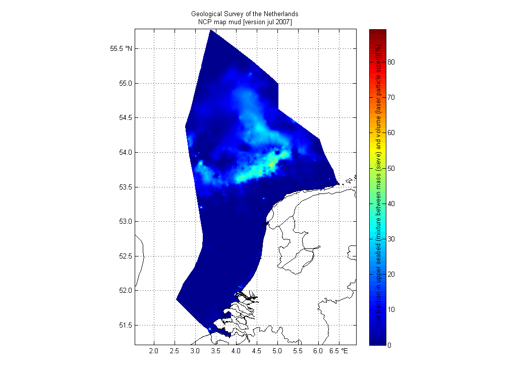
We used this image as Fig. 8 in our 2011 paper Mechanisms controlling the intra-annual mesoscale variability of SST and SPM in the southern North Sea.
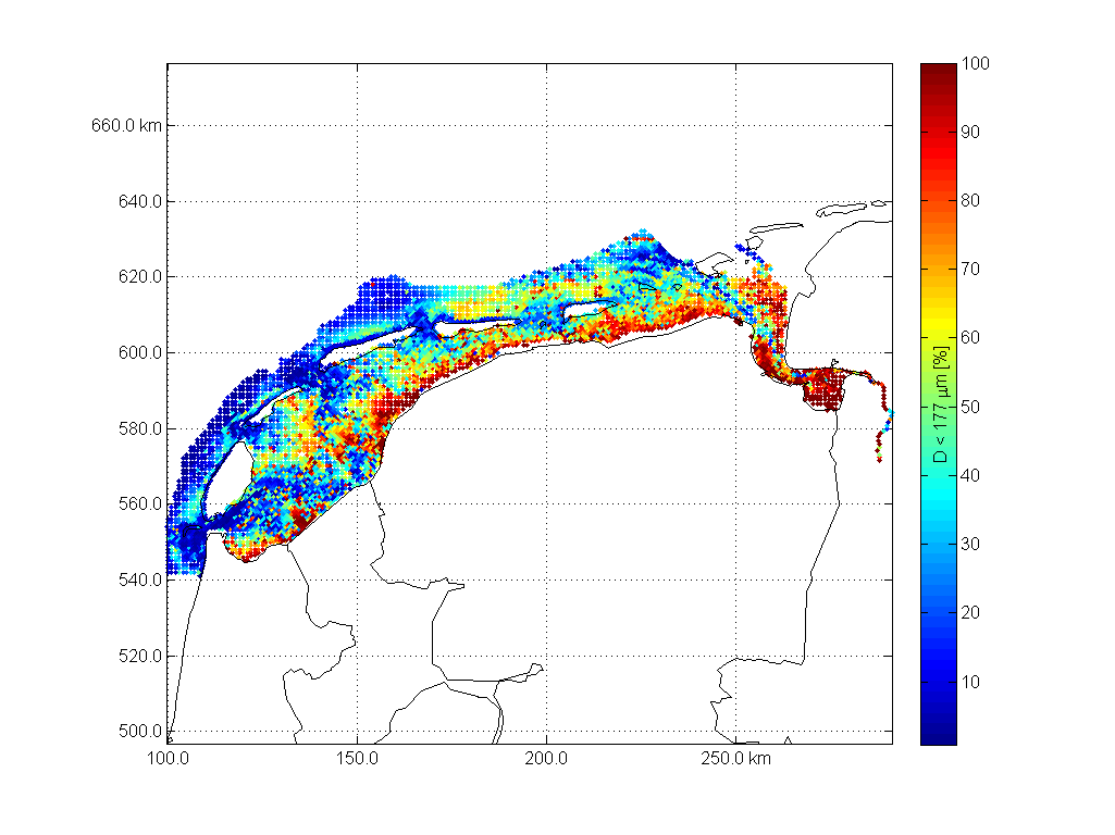
Sedimentatlas waddensea
A second Matlab example is a dataset used for Fig 9 in our 2008 paper Modeling large-scale cohesive sediment transport affected by small-scale biological activity. Here's an exmaple how to work with these data, find more script in
 %oetsettings
%% load data
 F          = 'http://opendap.deltares.nl/thredds/dodsC/opendap/rijkswaterstaat/sedimentatlas_waddenzee/korrel.nc';
 D.lon      = ncread(F,'lon');
 D.lat      = ncread(F,'lat');
 D.cumphi   = ncread(F,'cumphi');
 D.diameter = ncread(F,'diameter');
[D.x,D.y]   = convertCoordinates(D.lon,D.lat,'CS1.code',4326,'CS2.code',28992);% wgs84 to RD
fraction = 10; % fraction to work with

%% add coastal data
L = nc2struct('http://opendap.deltares.nl/thredds/dodsC/opendap/deltares/landboundaries/northsea.nc')
[L.x,L.y]   = convertCoordinates(L.lon,L.lat,'CS1.code',4326,'CS2.code',28992);% wgs84 to RD

%% plot data
caxis            ([0 100])
scatter          (D.x,D.y,20,D.cumphi(fraction,:),'.')
colorbarwithvtext(['D < ',num2str(D.diameter(fraction)),' \mum [%]'])
axis equal
grid on
tickmap          ('xy')
axis(axis)
hold on
plot(L.x,L.y,'k')
box on
print2screensize(['sedimentatlas_waddenzee_fraction_',num2str(D.diameter(fraction)),'mm'])

%% plot in Google Earth
 KMLscatter(D.lat ,D.lon ,D.cumphi(10,:),'fileName',['sedimentatlas_waddenzee.kml'],...
    'CBcolorTitle',['D < ',num2str(D.diameter(fraction)),' \mum [%]'],...
 'CBcolorbarlocation',{'W'});
As a part of the Delft Software Days (http://www.dsd-int.nl/) Deltares and 3TU.Datacentrum jointly organise the Data Science Symposium. The symposium will also be used as an occasion to celebrate the Dutch Data Prize 2012 that we won with OpenEarth.
Attendance is free of charge, but please make sure to register.
For more information see:
http://www.dsd-int.nl/symposium/data-science-symposium-addressing-4th-paradigm/