H6510 - Lowland hay meadows (Alopecurus pratensis, Sanguisorba officinalis)
General
General characteristics |
|
|---|---|
Common name |
Lowland hay meadows |
Region |
Europe |
Water system |
Rivers and streams |
Nature parameter |
Habitat types |
HR nr |
H6510 |
Fact sheet by |
M. Haasnoot |
Description habitat
General occurrence
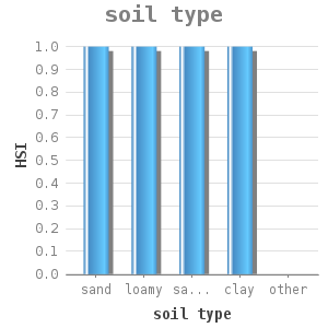
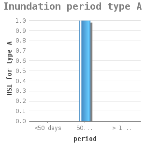
This habitat type comprises species-rich hay meadows on moderately fertile to basic soils, mostly sandy clay or loose clay. In The Netherlands, it concerns grass lands of the association Alopecurion pratensis (type A: Foxtail hay meadows) and Arrhenatherion elatioris (type B: Ever green grass hay meadows). The main ecological difference between the two associations is their sensitivity to flooding. The Alopecurion survives long term flooding during the winter period, mainly caused by indirect flooding (rising of groundwater level because of pressure of the river water level). The Arrhenatherion does not respond well to flooding. Both associations are part of the class of moderately fertile grasslands (Molinio-Arrhenatheretea) and have a large number of general species in common, including Meadow buttercup (Ranunculus acris), Creeping buttercup (Ranunculus repens), Common sorrel, (Rumex acetosa), Red klover (Trifolium pratense), White clover, (Trifolium repens), Common mouse-ear chickweed (Cerastium fontanum), Plantain (Plantago lanceolata), Red fescue. (Festuca rubra), Rough bluegrass (Poa trivialis), Smooth meadow-grass (Poa pratensis) and Sweet vernal grass (Anthoxanthum odoratum) #1.
Environmental conditions
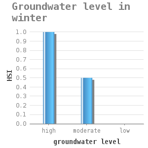
This habitat type comprises species-rich hay meadows on moderately fertile soils to basic soils, mostly sandy clay or loose clay. During the winter, the area is subject to prolonged flooding, but in summer, it can dry out. Inundation is not caused by direct flooding. A river water level rise in winter results in a higher ground water level in the lower lying areas resulting in inundation of that area #2.
Control and growth opportunities
Mowing is the most import control measurement.
A more intensive use of the agricultural function is a major threat to this habitat. The application of fertilizers, herbicides and deep drainage are the major threats. Other threats are hydraulic interventions, such as building dikes and a lowering of the ground water level #2. An adequate haying management en possible grazing later in the year could induce a prolonged preservation of the plant communities that are characteristic for this habitat type #2.
Dose-effect relations
The dose-effect relations for habitat type H6510 have been divided in relations for the two subtypes A and B, as both types have different habitat factors. Together they comprise the suitable areas for the H6510 area.
Flow chart
General dose-effect relations
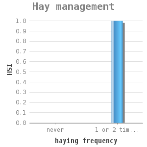
haying frequency |
HSI |
|---|---|
never |
0 |
1 or 2 times a year |
1 |
Reference: #2
Dose-effect relations for type A
Dose-effect relations for type B
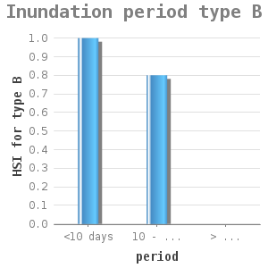
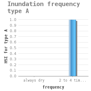
period |
HSI |
|---|---|
<10 days |
1 |
10 - 20 days |
0.8 |
> 20 days |
0 |
Note: This dose-effect relation applies to type B, the Evergreen grass hay meadows.
Reference: #2
Uncertainty and validation
![]() These dose-effect relations have not been validated.
These dose-effect relations have not been validated.
Applicability
These dose-effect relations apply to flood plains, wet grasslands of rivers and dikes.
Example project
At present, there is no example of a project available.
References
1 http://www.minlnv.nl/natura2000
2 Schaminée, J.H.J., Weeda, E.J. en Westhoff, V.. De vegetatie van Nederland. Deel 3. Graslanden - zomen en droge heiden. Opulus Press, Uppsala-Leiden. 1998.
3 Klijn, F., et al. Ruimte voor de rivier, ruimte voor de natuur? Alterra-rapport 513; WL-rapprt Q2824.10 2002