Grid display
The grid display is used in DELFT-FEWS for viewing grid time series. These grid time series can be dynamically animated against a map background (comparable to the main map display).
The Id of the grid display is identified in the DisplayInstanceDescriptors. When available on the file system, the name of the XML file for configuring the GridDisplay with an Id of FloodMapDisplay is for example:
FloodMapDisplay 1.00 default.xml
FloodMapDisplay |
File name for the Flood Map display configuration |
1.00 |
Version number |
default |
Flag to indicate the version is the default configuration (otherwise omitted). |

Figure 143 Example of a configuration of the Grid Display
Besides plotting a grid in the grid display, it is also possible to plot scalar data (Figure 10) and longitudinal profiles (figure 9).
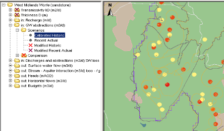
Figure 010 Example of a configuration of the scalar data in Grid Display

Figure 009 Example of a configuration of the longprofile in Grid Display

Figure 144 Root elements of the gridDisplay configuration
title
Name of the Grid Display. When opened this will appear in the title bar of the window.
gridPlotGroup
Definition of a group in the grid display. Each group may have its own set of maps and time series to display. Defining groups creates a tree view in the left of the display (see example above). Multiple instances may exist.
Attributes;
- id : Id of the display group- this is used in the tree view.
- name : Optional name of the display group- used for reference purposes only
description
Optional description of the display group/grid plot. Used for reference purposes only
highlight
Optional property to highlight the Group name in bold in the selection filter.
gridPlot
Definition of a grid plot within the display group. Each grid plot forms a node in the tree view. When a gridPlot is selected, the appropriate maps will be displayed and the time series data retrieved from the database.
Attributes;
- id : Id of the grid plot- this is used in the tree view.
- name : Optional name of the grid plot- used for reference purposes only
timeSeriesSet
Definition of the time series set to be displayed in the selected grid plot. This can refer to one location with valuetype grid or longitudinal profile, or it can refer to a locationSet of scalars. Contourlines can only be displayed in combination with a regular grid.
classBreaks
Definition of colours to use in displaying the dynamic grid. These are also shown in the legend on the left of the grid display (see example above).
geoMap
Definition of the maps used as a background to the dynamic grid displayed. The layout and zoom extent are also defined in this element.
Definition of class breaks
Figure 145 Elements of the configuration of class breaks